A New Map of the Kingdom of Poland, with its Dismembered Provinces and the Kingdom of Prussia.
Credit:
Ten plik został umieszczony w Wikimedia Commons w ramach współpracy z Geographicus Rare Antique Maps, organizacją specjalizującą się w kartografii oraz handlu rzadkimi mapami antykwarycznymi wysokiej jakości powstałymi w okresie od XV do XIX wieku.
Krótki link:
źródło:
Wymiary:
5000 x 3725 Pixel (5947384 Bytes)
Opis:
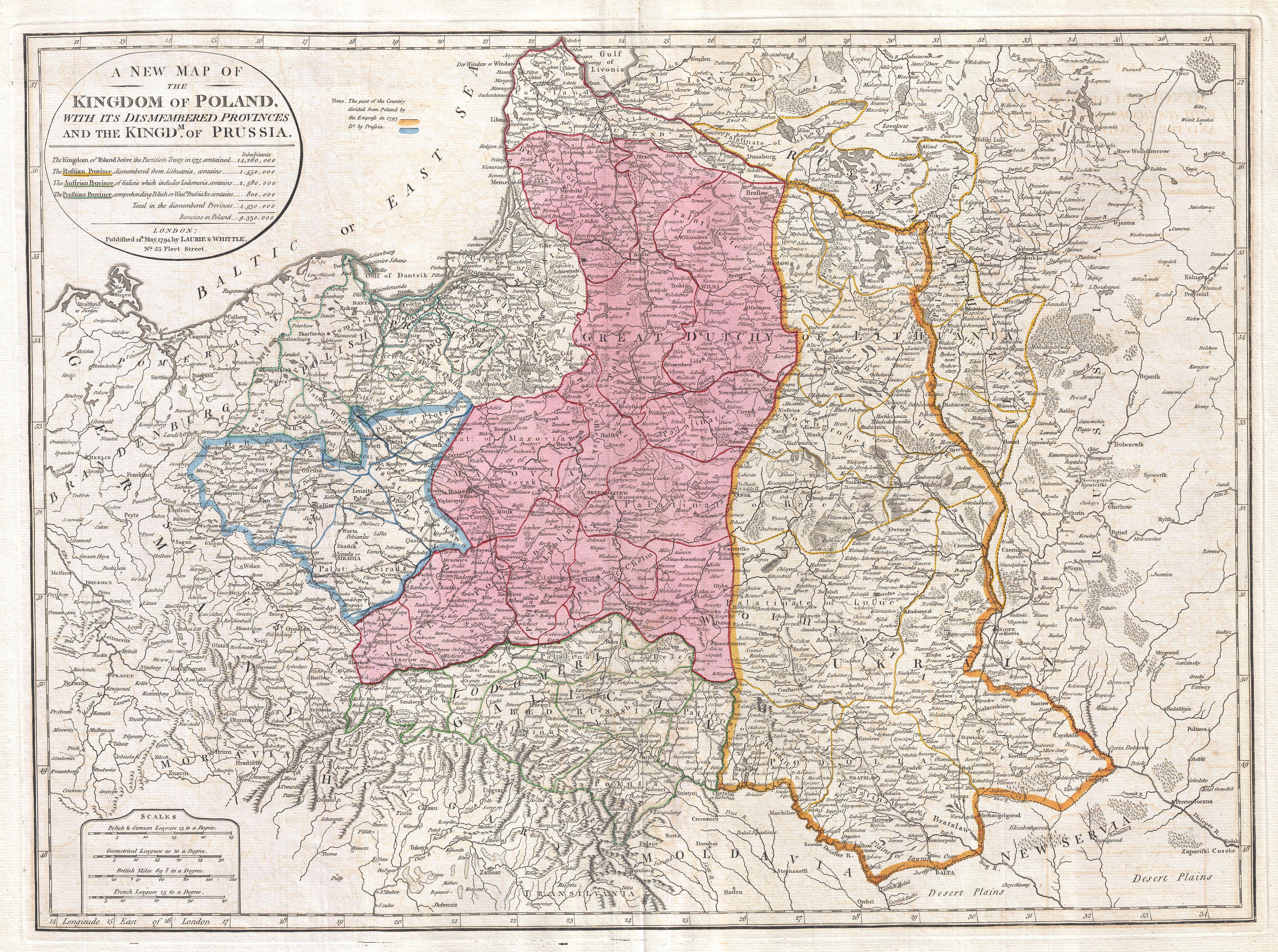
This important 1794 map by Thomas Kitchin depicts the Kingdom of Poland during the brief transitional period between the second and third partitions. Covers from Brandenburg to Russia and from the Gulf of Livonia to Moldova and Hungary, including all of Poland and the Grand Duchy of Lithuania, parts of Prussia, Russia, Livonia, Hungary, Germany and Austria. This map depicts Poland in 1794, immediately following the Second Partition of Poland in 1793. By the mid 18th century Poland, due to an inefficient and corrupt internal bureaucracy, had lost much of its autonomy to its aggressive and powerful neighbors, Russia, Austria and Prussia. The First Partition occurred in 1772 with Prussia occupying Poland's long coveted western territories, Austria seizing Galicia, and Russia taking part of Livonia. In the aftermath of the First Partition, the Second Partition was almost inevitable. Poland allied with Prussia to thwart the ambitions of Russia in the East. This, along with a number of other factors, lead to the War in Defense of the Constitution between Poland and Russia. Largely abandoned by their Prussian allies, Poland could not hope to stand against the powerful Russian military. Poland's defeat resulted in the loss of nearly 50% of its remaining territory to Russia and Prussia, who signed an accord in 1793. One year after this map was made, in 1795, the Third Partition of Poland would dissolve what remained of the reduced Polish-Lithuanian Commonwealth, ending Polish all autonomy in the 18th century. All text is in English. This map was drawn in London by Thomas Kitchin based on an earlier map of the region by D'Anville. Published by Laurie and Whittle in 1794 from their office at 53 Fleet Street, London, England.
Licencja:
Public domain
Komentarz do licencji:
|
Plik jest wierną reprodukcją fotograficzną dwuwymiarowego utworu, znajdującego się w domenie publicznej z następującego powodu:
Zgodnie z oficjalnym oświadczeniem Wikimedia Foundation wierne reprodukcje dwuwymiarowych utworów z domeny publicznej są w domenie publicznej, zajmowanie przeciwnego stanowiska godzi w samą ideę domeny publicznej (więcej w: Commons:When to use the PD-Art tag).
Niniejsza reprodukcja jest więc również własnością publiczną. Użytkowanie tego dzieła może być zabronione lub ograniczane przez miejscowe prawo na obszarze jego jurysdykcji; patrz: Commons:Reuse of PD-Art photographs. | ||||
Więcej informacji o licencji można znaleźć tutaj. Ostatnia aktualizacja: Sat, 15 Oct 2022 01:59:30 GMT