Chad regions numbered
Autor:
Attribution:
Obraz jest oznaczony jako „Wymagane uznanie autorstwa” (attribution required), ale nie podano żadnych informacji o uznaniu autorstwa. Prawdopodobnie parametr atrybucji został pominięty podczas korzystania z szablonu MediaWiki dla licencji CC-BY. Autorzy mogą znaleźć tutaj przykład prawidłowego korzystania z szablonów.
Credit:
Traced from various public domain maps.
Krótki link:
źródło:
Wymiary:
300 x 462 Pixel (11838 Bytes)
Opis:
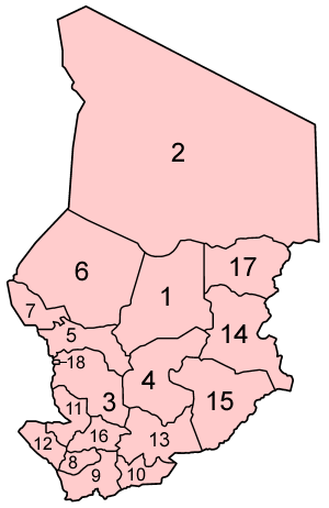
Map of the regions of Chad, numbered in English/French alphabetical order. (English = French except N'Djamena, which has a separate status, is numbered last. In French, it would be "Ville de N'Djamena", and last alphabetically.) This is the result of several days of research and staring at tiny maps, so it could still be incorrect, particularly in the southern quarter of the country. If you see any mistakes, PLEASE tell me.
14 prefectures of Chad :
Licencja:
Warunki licencji:
Creative Commons Attribution-Share Alike 3.0
Więcej informacji o licencji można znaleźć tutaj. Ostatnia aktualizacja: Fri, 08 May 2020 10:36:26 GMT