Majapahit Empire
Autor:
Attribution:
Obraz jest oznaczony jako „Wymagane uznanie autorstwa” (attribution required), ale nie podano żadnych informacji o uznaniu autorstwa. Prawdopodobnie parametr atrybucji został pominięty podczas korzystania z szablonu MediaWiki dla licencji CC-BY. Autorzy mogą znaleźć tutaj przykład prawidłowego korzystania z szablonów.
Credit:
Own work by uploader, see #References for references used creating the map.
Krótki link:
źródło:
Wymiary:
512 x 297 Pixel (536262 Bytes)
Opis:
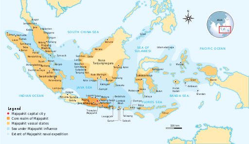
The Nusantara Archipelago during the height of Majapahit Empire in XIV century.
The red dot is Trowulan; Majapahit capital city. The dark orange area is core realm of Majapahit on eastern part of Java. The light orange area is vassal states of Majapahit mentioned in Nagarakretagama. The pale yellow is outer realm or independent states from Majapahit. The dark cyan is the sea area under influence or effective control of Majapahit. The light cyan is the extent of Majapahit naval expedition.
Licencja:
Komentarz do licencji:
Możesz wybrać, którą licencję chcesz zastosować.
Warunki licencji:
Creative Commons Attribution-Share Alike 3.0
Więcej informacji o licencji można znaleźć tutaj. Ostatnia aktualizacja: Wed, 11 Jan 2023 05:52:40 GMT
