Operationcartwheel
Autor:
Lofgren, Stephen J.
Credit:
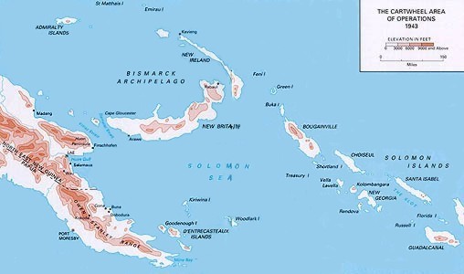
Northern Solomons: 22 February 1943–21 November 1944, Center Of Military History, United States Army, Washington, D.C. (pp6–7)
Krótki link:
źródło:
Wymiary:
508 x 300 Pixel (32994 Bytes)
Opis:
A topographical map from the US Army of the Territory of New Guinea and the northern Solomon Islands; the area in which Operation Cartwheel took place, from June 1943.
Licencja:
Public domain
Komentarz do licencji:
|
This image is in the public domain because it contains materials that originally came from the United States Army Center of Military History, subject to the following qualification.
Note: The images of all badges, insignia, decorations and medals on the "CMH Online" web site are produced by the United States Army Institute of Heraldry and protected by Title 18, United States Code, Section 704 and the Code of Federal Regulations (32 CFR, Part 507). Permission to use these images for commercial purposes must be obtained from The Institute of Heraldry prior to their use. |
 |
Więcej informacji o licencji można znaleźć tutaj. Ostatnia aktualizacja: Thu, 15 Sep 2022 17:20:48 GMT