Stonehenge plan
Autor:
Drawn by Adamsan
Attribution:
Obraz jest oznaczony jako „Wymagane uznanie autorstwa” (attribution required), ale nie podano żadnych informacji o uznaniu autorstwa. Prawdopodobnie parametr atrybucji został pominięty podczas korzystania z szablonu MediaWiki dla licencji CC-BY. Autorzy mogą znaleźć tutaj przykład prawidłowego korzystania z szablonów.
Credit:
- Cleal, Walker, & Montague, Stonehenge in its Landscape (London, English Heritage 1995)
- Pitts, M, Hengeworld (London, Arrow 2001)
Krótki link:
źródło:
Wymiary:
1220 x 1188 Pixel (184852 Bytes)
Opis:
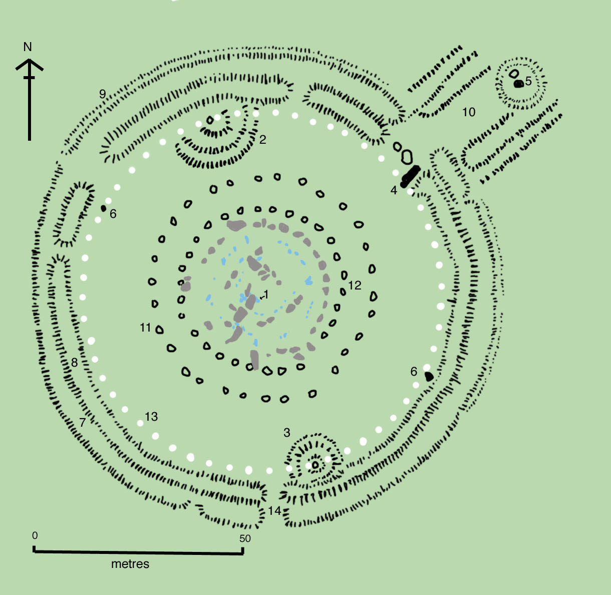
The site as of AD 2004. The plan omits the trilithon lintels for clarity. Holes that no longer, or never, contained stones are shown as open circles and stones visible today are shown coloured, grey for sarsen and blue for the imported stone, mainly bluestone.
Key to plan:
- 1 = The Altar Stone, a six ton monolith of green micaceous sandstone from Wales
- 2 = barrow without a burial
- 3 = "Barrows" (without burials)
- 4 = The fallen Slaughter Stone, 4.9 metres long
- 5 = The Heel Stone
- 6 = Two of originally four Station Stones
- 7 = Ditch
- 8 = Inner bank
- 9 = Outer bank
- 10 = The Avenue, a parallel pair of ditches and banks leading 3 km to the River Avon
- 11 = Ring of 30 pits called the Y Holes
- 12 = Ring of 29 pits called the Z Holes
- 13 = Circle of 56 pits, known as the Aubrey holes
- 14 = Smaller southern entrance
Licencja:
Warunki licencji:
Creative Commons Attribution-Share Alike 3.0
Więcej informacji o licencji można znaleźć tutaj. Ostatnia aktualizacja: Mon, 24 Oct 2022 15:51:49 GMT