Île-de-Batz
| gmina | |||||
 | |||||
| Państwo | |||||
|---|---|---|---|---|---|
| Region | |||||
| Departament | |||||
| Okręg | |||||
| Kod INSEE | 29082 | ||||
| Powierzchnia | 3,04 km² | ||||
| Populacja (1990) • liczba ludności |
| ||||
| • gęstość | 245 os./km² | ||||
| 48°44′40″N 4°00′39″W/48,744444 -4,010833 | |||||
| Portal | |||||
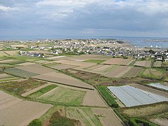
Île-de-Batz (bret. Enez-Vaz) to wyspa u wybrzeży Francji, zarazem miejscowość i gmina w regionie Bretania, w departamencie Finistère.
Według danych na rok 2005 gminę zamieszkiwały 594 osoby, a gęstość zaludnienia wynosiła 189 osób/km² (wśród 1269 gmin Bretanii Île-de-Batz plasuje się na 693. miejscu pod względem liczby ludności (dane na rok 1990), natomiast pod względem powierzchni na miejscu 1073.).
Bibliografia
- Francuski urząd statystyczny. (fr.).
Media użyte na tej stronie
Autor: Eric Gaba (Sting - fr:Sting), Licencja: CC BY-SA 3.0
Blank administrative map of the department of Finistère, France, for geo-location purpose, with distinct boundaries for departments and arrondissements.
Autor: Superbenjamin, Licencja: CC BY-SA 4.0
Blank administrative map of France for geo-location purpose, with regions and departements distinguished. Approximate scale : 1:3,000,000
Autor: Eric Gaba (Sting - fr:Sting), Licencja: CC BY-SA 3.0
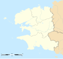
Blank administrative map of the region of Bretagne, France, for geo-location purpose, with distinct boundaries for regions, departments and arrondissements.
Autor: Ec.Domnowall (vectorisation SVG), Licencja: CC BY-SA 3.0
Bannière armoriée de l'Île de Batz
Autor: Autor nie został podany w rozpoznawalny automatycznie sposób. Założono, że to Pr~commonswiki (w oparciu o szablon praw autorskich)., Licencja: CC BY 2.5
Porz Kernog auf der Ile de Batz, vom Hafen aus fotografiert.
Autor: Metalheart, Licencja: CC BY-SA 3.0
General overview of the Batz island from the top of the lighthouse


