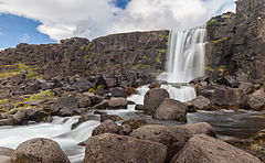
Öxarárfoss
(c) Diego Delso, CC BY-SA 4.0 | |
| Kontynent | |
|---|---|
| Państwo | |
| Wysokość | 22 m |
| Rzeka zasilająca | |
(c) Diego Delso, CC BY-SA 4.0
Öxarárfoss – 22-metrowej wysokości wodospad na Islandii, w Parku Narodowym Þingvellir, położony na rzece Öxará.
Linki zewnętrzne
Media użyte na tej stronie
Öxarárfoss, Parque Nacional de Þingvellir, Suðurland, Islandia, 2014-08-16, DD 027.JPG
(c) Diego Delso, CC BY-SA 4.0
Öxarárfoss, Suðurland, Iceland
(c) Diego Delso, CC BY-SA 4.0
Öxarárfoss, Suðurland, Iceland
Öxarárfoss, Parque Nacional de Þingvellir, Suðurland, Islandia, 2014-08-16, DD 029.JPG
(c) Diego Delso, CC BY-SA 4.0
Öxarárfoss, Þingvellir National Park, Suðurland, Iceland. The 20 meter high waterfall flows from the Öxará river and is one of the most visited attractions in Þingvellir National Park, one of the two World Heritage sites in Iceland.
(c) Diego Delso, CC BY-SA 4.0
Öxarárfoss, Þingvellir National Park, Suðurland, Iceland. The 20 meter high waterfall flows from the Öxará river and is one of the most visited attractions in Þingvellir National Park, one of the two World Heritage sites in Iceland.
Steel pog.svg
Shiny LightSteelBlue button/marker widget. Used to mark the location of something such as a tourist attraction.
Shiny LightSteelBlue button/marker widget. Used to mark the location of something such as a tourist attraction.
Iceland relief map.jpg
Autor:
Location map of Iceland
Autor:
- Iceland_location_map.svg: NordNordWest
- derivative work: Виктор В (talk)
Location map of Iceland


