Łyman
 | |||||
| Państwo | |||||
|---|---|---|---|---|---|
| Obwód | |||||
| Powierzchnia | 18,2 km² | ||||
| Populacja (2021) • liczba ludności |
| ||||
| Nr kierunkowy | +380 6261 | ||||
| Kod pocztowy | 84400-84409 | ||||
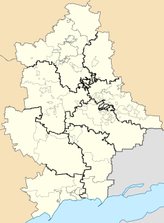
Położenie na mapie Ukrainy (c) Karte: NordNordWest, Lizenz: Creative Commons by-sa-3.0 de | |||||
| Strona internetowa | |||||
| Portal | |||||
Łyman[2] (ukr. Лиман, w latach 1925–2016 Krasnyj Łyman, ukr. Красний Лиман) – miasto w obwodzie donieckim, rejonie kramatorskim na Ukrainie. Była siedziba władz rejonu łymańskiego. Większość ludności jest zatrudniona na kolei i w kompleksie rolno-przemysłowym.
Historia
Łyman powstał w 1667 r., jako osada Kozaków pułku izjumskiego. W 1825 r. został przekształcony w osadę wojskową. W 1911 r. w pobliżu miejscowości poprowadzono linię kolejową i wybudowano stację. W 1925 r. została ona przemianowana na Krasnyj Łyman. W latach 1932–1933 wielu mieszkańców zmarło w wyniku Hołodomoru. W 1938 r. Krasnyj Łyman otrzymał prawa miejskie. W czasie II wojny światowej, od 7 lipca 1942 do 31 stycznia 1943 r., miasto znajdowało się pod okupacją niemiecką. Działały tu oddziały partyzanckie.
12 kwietnia 2014 r., 5. dnia po ogłoszeniu „Donieckiej Republiki Ludowej”, separatyści podjęli próbę ujęcia miejscowego posterunku policji. Burmistrz Łeonid Perebeinis prowadził negocjacje z uzbrojonym i agresywnym tłumem rosyjskich bojowników. W trakcie negocjacji uzgodniono, że separatyści opuszczą miasto bez walki. Jednak już 30 kwietnia uzbrojeni terroryści wdarli się na sesję rady miejskiej i pod groźbą użycia broni wzięli deputowanych i gminę jako zakładników i zmusili władze miasta do uwzględnienia w głosowaniu kwestii uznania niepodległości „Donieckiej Republiki Ludowej”.[3]. 3 czerwca władze ukraińskie odzyskały kontrolę nad Krasnym Łymanem. 4 lutego 2016 Rada Najwyższa Ukrainy w ramach procesu dekomunizacji przywróciła nazwę Łyman[4]. Zmiana nazwy weszła w życie 18 lutego 2016.
Podczas inwazji Rosji w Ukrainę, pod koniec maja 2022 r. Łyman został zdobyty przez wojska rosyjskie, po kilkudniowych walkach wokół miasta z użyciem artylerii[5]. Podczas kontrofensywy ukraińskiej na północnym wschodzie wojska ukraińskie podeszły pod miasto 10 września, lecz Rosjanie przez kolejne tygodnie bronili się w mieście[5]. Po otoczeniu Łymanu od północy pod koniec września, siły ukraińskie weszły do miasta 1 października[5]. Ponad 90% budynków mieszkalnych zostało zniszczonych przez rosyjskie wojska[6].
Demografia
- 2013 – 23 413
- 2021 – 20 469[1]
Religia
W mieście znajduje się żeński monaster Opieki Matki Bożej w jurysdykcji Ukraińskiego Kościoła Prawosławnego Patriarchatu Moskiewskiego[7].
Przypisy
- ↑ a b Чисельність наявного населення України на 1 січня 2021 року, ukrcensus.gov.ua [dostęp 2021-08-19] (ukr.).
- ↑ Polski egzonim przyjęty na 121. posiedzeniu KSNG.
- ↑ Красний Лиман – українська північ Донбасу. maidan.org.ua, 2014-06-13. [dostęp 2022-09-28]. (ukr.).
- ↑ ПОСТАНОВА Верховної Ради України Про перейменування окремих населених пунктів та районів. zakon.rada.gov.ua. [dostęp 2022-09-28]. (ukr.).
- ↑ a b c Bartosz Wieliński: Ukraińcy wkroczyli do Łymanu. Kadyrow do Putina: Zrzuć atomówkę. wyborcza.pl, 2022-10-01. [dostęp 2022-10-01].
- ↑ У Лимані та Святогірську знищено понад 90% будинків від дій окупантів. espreso.tv, 2022-10-18. [dostęp 2022-10-19]. (ukr.).
- ↑ Покровский женский монастырь. gorlovka-eparhia.com.ua. [dostęp 2021-11-05]. (ros.).
Media użyte na tej stronie
(c) Karte: NordNordWest, Lizenz: Creative Commons by-sa-3.0 de
Location map of Ukraine
Autor: Лиманська ОТГ, Licencja: CC BY-SA 4.0
A rectangular flag with an aspect ratio of 2:3, which consists in equal proportion of three horizontal stripes (from top to bottom): green, blue and yellow, which determine that the territory and natural treasures of the Lyman ATC (green) are an integral part of the territory and treasury of natural wealth of Ukraine (a combination of blue and yellow - the colors of the State Flag of Ukraine) and symbolize the natural features of the territory of the UTC: green - forest; blue - water bodies, yellow - steppe.
In addition, the combination of these colors determines (by its meaning in heraldry) - the combination in the life of the community of such concepts as: Freedom, Joy, Hope, Health (green); Glory, Honor, Loyalty, Sincerity (blue); Supremacy, Greatness, Respect, Splendor, Wealth (yellow).
In the upper left part of the flag of the AH, at a distance of 1/9 of the flag's length from the hoist, there are the elements of the coat of arms of Lyman ATC - a schematic image of a grain ear, a locomotive and a schematic image of the railway emblem "wings" so that the image of the ear is located on the green color of the Flag, and the locomotive and "wings" on the blue. The area of the elements of the ATC Coat of Arms is 1/20 of the area of the ATC Flag.Autor: Лиманська ОТГ, Licencja: CC BY-SA 4.0
A quadrangular shield with a sharp base (traditional English) with a crimson border. In the center of the shield there is a gold pale with a wheat spicule proper, over a pine forest in fess on a green field. In the center of the base is a locomotive and wings (in the picture black).
The border of the shield is crimson - the main color of the Flag of the Izyum Sloboda Cossack Regiment of the time when the Cossacks protected farmers from raids of devastators and destroyers, having built fortifications that laid the foundation of the first settlements of the united territorial community by the Cossacks of this connection. The green color with a vector image of a pine forest is the beauty of the region, the peculiarity of the landscape and the presence of healing factors of a natural nature. Blue color - a large number of water bodies. Schematic image of an ear of wheat on a golden background - determines the status of the region as an agricultural one with a large amount of fertile land and a developed agricultural sector.
The locomotive and the schematic image of the railway emblem "wings" - defines the railway transport enterprises - the main budget-forming industry of the ATC, the basis of its financial well-being.Герб Донецької области (Україна)
Autor: RosssW, Licencja: CC BY-SA 4.0
Districts of the Donetsk region of Ukraine according to the Decree of the Verkhovna Rada of July 17, 2020 against the background of the old administrative boundaries of districts and cities of regional significance (city councils) and displaying the territories of the unrecognized DPR that are not controlled by the Ukrainian authorities.
Autor: Green Zero, Licencja: CC BY-SA 4.0
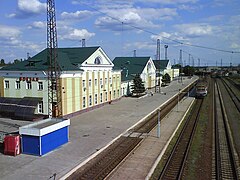
Lyman (Ukraine) railway station buildings, after the restoration


