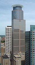
225 South Sixth
 | |
| Państwo | |
|---|---|
| Miejscowość | Minneapolis |
| Wysokość całkowita | 236 m |
| Kondygnacje | 56 |
| Rozpoczęcie budowy | 1989 |
| Ukończenie budowy | 1992 |
| Strona internetowa | |
225 South Sixth – wieżowiec w Minneapolis, będący drugą najwyższą budowlą w mieście, po IDS Tower. Początkowo pełnił funkcję siedziby First Bank, po przeniesieniu się tej instytucji finansowej do innego, znacznie mniejszego budynku, stał się uniwersalnym biurowcem.
Pod względem wysokości znajduje się na 137. miejscu na świecie.
Media użyte na tej stronie
Autor: Uwe Dedering, Licencja: CC BY-SA 3.0
Location map of the USA (without Hawaii and Alaska).
EquiDistantConicProjection:
Central parallel:
* N: 37.0° N
Central meridian:
* E: 96.0° W
Standard parallels:
* 1: 32.0° N
* 2: 42.0° N
Made with Natural Earth. Free vector and raster map data @ naturalearthdata.com.
Formulas for x and y:
x = 50.0 + 124.03149777329222 * ((1.9694462586094064-({{{2}}}* pi / 180))
      * sin(0.6010514667026994 * ({{{3}}} + 96) * pi / 180))
y = 50.0 + 1.6155950752393982 * 124.03149777329222 * 0.02613325650382181
      - 1.6155950752393982  * 124.03149777329222 *
     (1.3236744353715044  - (1.9694462586094064-({{{2}}}* pi / 180))
      * cos(0.6010514667026994 * ({{{3}}} + 96) * pi / 180))
The flag of Navassa Island is simply the United States flag. It does not have a "local" flag or "unofficial" flag; it is an uninhabited island. The version with a profile view was based on Flags of the World and as a fictional design has no status warranting a place on any Wiki. It was made up by a random person with no connection to the island, it has never flown on the island, and it has never received any sort of recognition or validation by any authority. The person quoted on that page has no authority to bestow a flag, "unofficial" or otherwise, on the island.
en:225 South Sixth in en:Minneapolis, Minnesota as viewed from the observation deck of the en:Foshay Tower. Photo taken on June 8, 2005 by User:Mulad. Hereby released into the public domain.
Autor: Alexrk2, Licencja: CC BY 3.0
Ta mapa została stworzona za pomocą GeoTools.


