Aberdeen (stacja kolejowa w Wielkiej Brytanii)
| ||
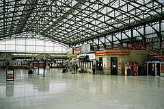
 Hala dworcowa w 2004 r. | ||
| Państwo | ||
| Kraj | ||
| Miejscowość | Aberdeen | |
| Zarządca | ||
| Liczba pasażerów (2009-10) | 2,657 mln[1] | |
| Dane techniczne | ||
| Liczba peronów | 7 | |
| Linie kolejowe | ||
| ||
Położenie na mapie Aberdeen Contains Ordnance Survey data © Crown copyright and database right, CC BY-SA 3.0 | ||
Położenie na mapie Wielkiej Brytanii (c) Karte: NordNordWest, Lizenz: Creative Commons by-sa-3.0 de | ||
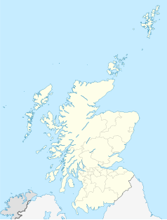
Położenie na mapie Szkocji | ||
| Strona internetowa | ||
| Portal | ||
Aberdeen – stacja kolejowa w Aberdeen, w Szkocji. Otwarcie stacji nastąpiło w 1867. Posiada 7 peronów i obsługuje około 2,65 mln pasażerów rocznie.
Galeria
Przypisy
- ↑ Station Usage 2009-10 (ang.). Office for Rail Regulation. [dostęp 2011-07-03]. [zarchiwizowane z tego adresu (2011-05-04)].
Media użyte na tej stronie
(c) Karte: NordNordWest, Lizenz: Creative Commons by-sa-3.0 de
Location map of the United Kingdom
Autor: Alexandra Lanes, Licencja: Copyrighted free use
The concourse of Aberdeen railway station
Autor: Zboralski, Licencja: CC0
Main entry to Railway Station Hall in Aberdeen
(c) Eric Gaba, NordNordWest, CC BY-SA 3.0
Location map of Scotland, United Kingdom
Contains Ordnance Survey data © Crown copyright and database right, CC BY-SA 3.0
Blank map of Aberdeen, UK with the following information shown:
- Administrative borders
- Coastline, lakes and rivers
- Roads and railways
- Urban areas
Equirectangular map projection on WGS 84 datum, with N/S stretched 180%
Geographic limits:
- West: 2.42W
- East: 2.01W
- North: 57.25N
- South: 57.06N


