Abisko
 | |
| Państwo | |
|---|---|
| Region | |
| Populacja • liczba ludności |
|
| Portal | |
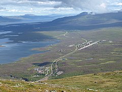
Abisko – wieś położona w północnej Szwecji oraz nazwa parku narodowego[1], na terenie którego po części się znajduje.
Geograficznie Abisko jest położone w Laponii, przy granicy z Norwegią, należy do zagłębia Kiruna, najbardziej oddalonego na północ i największego zagłębia Szwecji. Leży na brzegu jeziora Torneträsk. Znajduje się około 195 km na północ od Koła podbiegunowego północnego.
Ze względu na to, że jest jedną z najdalej wysuniętych na północ miejscowości w Szwecji oraz jej wyniesienie ponad otaczający teren, stała się popularnym punktem obserwacji zorzy polarnej[2].
Przypisy
- ↑ Andrzej i Paweł Garscy: Park Narodowy Abisko (Szwecja), Arktyczny ogród i kanion rzeki Abiskojåkka.. Wędrówki po Skandynawii.
- ↑ Aurora Sky Station (ang.). [dostęp 2013-03-28].
Media użyte na tej stronie
(c) Lokal_Profil, CC BY-SA 2.5
This coat of arms was drawn based on its blazon which – being a written description – is free from copyright. Any illustration conforming with the blazon of the arms is considered to be heraldically correct. Thus several different artistic interpretations of the same coat of arms can exist. The design officially used by the armiger is likely protected by copyright, in which case it cannot be used here.
Individual representations of a coat of arms, drawn from a blazon, may have a copyright belonging to the artist, but are not necessarily derivative works.
Autor: Erik Frohne, Licencja: CC BY-SA 3.0
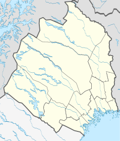
Location map of Norrbotten County in Sweden
Equirectangular projection, N/S stretching 257 %. Geographic limits of the map:
- N: 69.10° N
- S: 64.90° N
- W: 15.10° E
- E: 24.30° E
Autor: Marmelad, Licencja: CC BY-SA 2.5
This coat of arms was drawn based on its blazon which – being a written description – is free from copyright. Any illustration conforming with the blazon of the arms is considered to be heraldically correct. Thus several different artistic interpretations of the same coat of arms can exist. The design officially used by the armiger is likely protected by copyright, in which case it cannot be used here.
Individual representations of a coat of arms, drawn from a blazon, may have a copyright belonging to the artist, but are not necessarily derivative works.
Autor: Ojan, Licencja: CC0
Picture of Abisko in northern Sweden, taken from the mountain Nuolja. In the foreground, Abisko Turiststation and the bottom part of the Abisko canyon can be seen. Further away is the village Abisko Östra. To the left in the picture, the lake Torneträsk can be seen.


