Acapulco
| |||
 | |||
| |||
| Dewiza: Perła Pacyfiku | |||
| Państwo | |||
| Stan | |||
| Burmistrz | Luis Walton Aburto (2012-2015) | ||
| Powierzchnia | 1882,6 km² | ||
| Wysokość | 30 m n.p.m. | ||
| Populacja (2010) • liczba ludności | 673 479[1]. | ||
| Nr kierunkowy | 744 | ||
| Kod pocztowy | 39300-39937 | ||
| Strona internetowa | |||
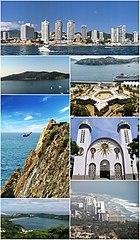
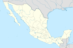
Acapulco de Juárez – miasto, port i kurort w Meksyku (stan Guerrero) nad Oceanem Spokojnym. Liczba mieszkańców: 673 tys. (2010). Zespół miejski około 1,1 mln mieszkańców.
Acapulco jest głównym portem w stanie Guerrero, u wybrzeży Oceanu Spokojnego w Meksyku. Leży 300 km na południowy zachód od stolicy kraju miasta Meksyk. Usytuowane jest w półkolistej, głębokiej zatoce. Zbudowane jest na wąskim pasie niskiego lądu. Ma on 800 metrów szerokości pomiędzy linią brzegową a górami otaczającymi zatokę. Uważane jest za jeden z najlepszych i najważniejszych portów na tym wybrzeżu Pacyfiku. Tu przecinają się szlaki handlowe biegnące między Panamą a Kalifornią w USA. Znajduje się tu także międzynarodowy port lotniczy.
Jednym z najbardziej znanych zabytków miasta jest hiszpański fort San Diego.
Klimat
Klimat gorący i wilgotny z częstymi opadami w okresie letnim, natomiast w miesiącach zimowych opady znikome bądź niewystępujące.
Historia
W 1531 roku w pobliże dzisiejszego portu dotarł Hernán Cortés. W 1550 roku założono osadę. Prawa miejskie zostały nadane w 1599 roku. Od XVII wieku Acapulco było głównym węzłem transportowym tej części świata.
Miasta partnerskie
 Arequipa – Peru
 Beverly Hills – Stany Zjednoczone
 Cannes – Francja
 Manila – Filipiny
 Netanja – Izrael
 Neapol – Włochy
 Onjuku – Japonia
 Ordicia – Hiszpania
 Quebec – Kanada
 Sendai – Japonia
 Qingdao – Chiny
 Gold Coast – Australia
 Panaji – Indie
 Rijad – Arabia Saudyjska
 Callao – Peru
 Puerto Vallarta – Meksyk
 Soczi – Rosja
 McAllen – Stany Zjednoczone
 Cuernavaca – Meksyk
 Jałta – Ukraina
 Guanajuato – Meksyk
 Monachium – Niemcy
 Hạ Long – Wietnam
 Baku – Azerbejdżan
 Larnaka – Cypr
 Ejlat – Izrael
 Boca del Río – Meksyk
 Puerto Quetzal – Gwatemala
 Bandar Torkaman – Iran
Sport
Od 1993 roku w Acapulco odbywa się turniej tenisa ziemnego Abierto Mexicano Telcel.
Zobacz też
Przypisy
- ↑ Principales resultados por localidad 2010 (ITER) (hiszp.). Instituto Nacional de Estadística, Geografía e Informática.. [dostęp 2015-08-03].
Bibliografia
- Encyklopedia Audiowizualna Britannica – Geografia I, Rafał Jasiulewicz (red.), Leszek Baraniecki, Poznań: Wydawnictwo Kurpisz, 2006, ISBN 83-60563-07-1, ISBN 978-83-60563-07-6, ISBN 83-60563-04-7, ISBN 978-83-60563-04-5, ISBN 1-59339-330-X, ISBN 978-1-59339-330-4, OCLC 838992809.
Linki zewnętrzne
Media użyte na tej stronie
The flag of Navassa Island is simply the United States flag. It does not have a "local" flag or "unofficial" flag; it is an uninhabited island. The version with a profile view was based on Flags of the World and as a fictional design has no status warranting a place on any Wiki. It was made up by a random person with no connection to the island, it has never flown on the island, and it has never received any sort of recognition or validation by any authority. The person quoted on that page has no authority to bestow a flag, "unofficial" or otherwise, on the island.
Flag of Israel. Shows a Magen David (“Shield of David”) between two stripes. The Shield of David is a traditional Jewish symbol. The stripes symbolize a Jewish prayer shawl (tallit).
Autor: Pedro A. Gracia Fajardo, escudo de Manual de Imagen Institucional de la Administración General del Estado, Licencja: CC0
Flaga Hiszpanii
The Flag of India. The colours are saffron, white and green. The navy blue wheel in the center of the flag has a diameter approximately the width of the white band and is called Ashoka's Dharma Chakra, with 24 spokes (after Ashoka, the Great). Each spoke depicts one hour of the day, portraying the prevalence of righteousness all 24 hours of it.
escudo acapulco
Location Map of en:Estado de Guerrero Equirectangular projection, Geographic limits of the map:
- N: 18.96° N
- S: 16.25° N
- W: 102.39° W
- E: 97.87° W


