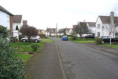
Acklington
| ||
(c) Walter Baxter, CC BY-SA 2.0 | ||
| Państwo | ||
| Region | North East England | |
| Hrabstwo | Northumberland | |
| Nr kierunkowy | 01670 | |
| Kod pocztowy | NE65 | |
Położenie na mapie Northumberland Contains Ordnance Survey data © Crown copyright and database right, CC BY-SA 3.0 | ||
| Portal | ||
Acklington – niewielka miejscowość w Wielkiej Brytanii, w północnej Anglii, w regionie North East England, hrabstwie Northumberland.
W latach 1938 – 1972 znajdowało się tu lotnisko RAFu, na którego terenie wybudowano po roku 1972 dwa więzienia: HMP "Acklington" dla więźniów pełnoletnich oraz HMP "Castington" dla niepełnoletnich.
Media użyte na tej stronie
Autor: NordNordWest, Licencja: CC BY-SA 3.0
Location map of the United Kingdom
Contains Ordnance Survey data © Crown copyright and database right, CC BY-SA 3.0
Map of Northumberland, UK with the following information shown:
- Administrative borders
- Coastline, lakes and rivers
- Roads and railways
- Urban areas
Equirectangular map projection on WGS 84 datum, with N/S stretched 170%
Geographic limits:
- West: 2.85W
- East: 1.35W
- North: 55.83N
- South: 54.77N


