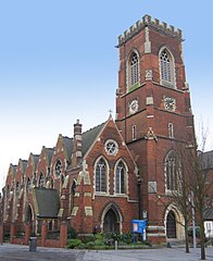
Acton (Londyn)
| ||||
| ||||
 Kościół św. Marii w centrum Acton | ||||
| Państwo | ||||
| Kraj | ||||
| Region | Wielki Londyn | |||
| Miasto | Londyn | |||
| Gmina | Ealing | |||
Położenie na mapie Wielkiego Londynu Contains Ordnance Survey data © Crown copyright and database right, CC BY-SA 3.0 | ||||
Położenie na mapie Wielkiej Brytanii (c) Karte: NordNordWest, Lizenz: Creative Commons by-sa-3.0 de | ||||
| 51°30′38″N 0°15′46″W/51,510519 -0,262661 | ||||
| Portal | ||||
Acton – dzielnica w Londynie, wchodząca w skład gminy London Borough of Ealing, a także częściowo London Borough of Hammersmith and Fulham oraz London Borough of Hounslow. Nazwa pochodzi od staroangielskich słów ac (dąb) oraz tun (farma)[1].
Kościoły
- Acton Hill Church
Przypisy
- ↑ Anthony David Mills, Dictionary of London Place Names, Oxford, 2000, s. 2, ISBN 978-0192801067 (ang.).
Media użyte na tej stronie
Contains Ordnance Survey data © Crown copyright and database right, CC BY-SA 3.0
Map of Greater London, UK with the following information shown:
- Administrative borders
- Coastline, lakes and rivers
- Roads and railways
- Urban areas
The data includes both primary routes and railway lines.
Equirectangular map projection on WGS 84 datum, with N/S stretched 160%
Geographic limits:
- West: 0.57W
- East: 0.37E
- North: 51.72N
- South: 51.25N
(c) Karte: NordNordWest, Lizenz: Creative Commons by-sa-3.0 de
Location map of the United Kingdom
Flag of England. Saint George's cross (a red cross on a white background), used as the Flag of England, the Italian city of Genoa and various other places.
St Mary's parish church, Acton, London W3, seen from the northeast.
This image was originally on Wikipedia, and is being moved by its author under the same name.


