Acton Central
| ||
 Budynek stacji | ||
| Państwo | ||
| Kraj | ||
| Miejscowość | Londyn | |
| Lokalizacja | London Borough of Ealing | |
| Zarządca | ||
| Liczba pasażerów (2009-10) | 957 000 | |
Położenie na mapie gminy Ealing  Contains Ordnance Survey data © Crown copyright and database right, CC BY-SA 3.0 | ||
Położenie na mapie Wielkiej Brytanii  (c) Karte: NordNordWest, Lizenz: Creative Commons by-sa-3.0 de | ||
Położenie na mapie Anglii  | ||
Położenie na mapie Wielkiego Londynu  Contains Ordnance Survey data © Crown copyright and database right, CC BY-SA 3.0 | ||
| Strona internetowa | ||
| Portal | ||
Acton Central – stacja kolejowa w Londynie, na terenie London Borough of Ealing, zarządzana i obsługiwana przez London Overground[1] jako część North London Line. W systemie londyńskiej komunikacji miejskiej należy do trzeciej strefy biletowej[2]. W roku statystycznym 2009-10 skorzystało z niej ok. 957 tysięcy pasażerów[3].
Galeria
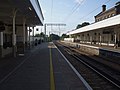
Perony

Tablica z nazwą stacji
Przypisy
- ↑ Acton Central (ACC) (ang.). National Rail. [dostęp 2011-07-02].
- ↑ Mapa stref biletowych (ang.). Transport for London. [dostęp 2011-07-02].
- ↑ 2009-10 Station Usage (ang.). Office for Rail Regulation. [dostęp 2011-07-02]. [zarchiwizowane z tego adresu (2011-05-04)].
| Gospel Oak – Barking |
|
|---|---|
| North London Line |
|
| South London Line |
|
| Watford DC Line | |
| West London Line |
|
| East London Line |
![]()
Media użyte na tej stronie
United Kingdom adm location map.svg
(c) Karte: NordNordWest, Lizenz: Creative Commons by-sa-3.0 de
Location map of the United Kingdom
(c) Karte: NordNordWest, Lizenz: Creative Commons by-sa-3.0 de
Location map of the United Kingdom
Greater London UK location map 2.svg
Contains Ordnance Survey data © Crown copyright and database right, CC BY-SA 3.0
Contains Ordnance Survey data © Crown copyright and database right, CC BY-SA 3.0
Map of Greater London, UK with the following information shown:
- Administrative borders
- Coastline, lakes and rivers
- Roads and railways
- Urban areas
The data includes both primary routes and railway lines.
Equirectangular map projection on WGS 84 datum, with N/S stretched 160%
Geographic limits:
- West: 0.57W
- East: 0.37E
- North: 51.72N
- South: 51.25N


Flag of England.svg
Flag of England. Saint George's cross (a red cross on a white background), used as the Flag of England, the Italian city of Genoa and various other places.
Flag of England. Saint George's cross (a red cross on a white background), used as the Flag of England, the Italian city of Genoa and various other places.
Ealing London UK blank ward map.svg
Contains Ordnance Survey data © Crown copyright and database right, CC BY-SA 3.0
Contains Ordnance Survey data © Crown copyright and database right, CC BY-SA 3.0
Blank map of the London Borough of Ealing, showing electoral wards used from 2002 to 2022.
Equirectangular map projection on WGS 84 datum, with N/S stretched 160%
Geographic limits:
- West: 0.425W
- East: 0.24W
- North: 51.565N
- South: 51.485N
London Overground logo.svg
This is a logo owned by Transport for London for London Overground.
This is a logo owned by Transport for London for London Overground.
Acton Central stn building.JPG
Autor: Sunil060902, Licencja: CC BY-SA 3.0
Acton Central station building. Much of the building has been converted to a pub, visible on the right.
Autor: Sunil060902, Licencja: CC BY-SA 3.0
Acton Central station building. Much of the building has been converted to a pub, visible on the right.

Acton Central stn signage.JPG
Autor: Sunil060902, Licencja: CC BY-SA 3.0
Acton Central station platform signage, in Overground colours (temporary as of October 2008)
Autor: Sunil060902, Licencja: CC BY-SA 3.0
Acton Central station platform signage, in Overground colours (temporary as of October 2008)

Acton Central stn look south.JPG
Autor: Sunil060902, Licencja: CC BY-SA 3.0
Acton Central station looking westbound (actually south here)
Autor: Sunil060902, Licencja: CC BY-SA 3.0
Acton Central station looking westbound (actually south here)