Ad-Dachla-Wadi az-Zahab
 | |
| Państwo | |
|---|---|
| Siedziba | |
| Powierzchnia | 142 865 km² |
| Populacja (2014) • liczba ludności |
|
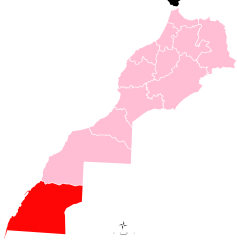
Położenie na mapie Maroka | |
Ad-Dachla-Wadi az-Zahab (arab. الداخلة - وادي الذهب; fr. Dakhla-Oued Ed-Dahab) – region administracyjny w Maroku, w południowej części kraju, obejmujący południową część spornego terytorium Sahary Zachodniej. W 2014 roku liczył 143 tysiące mieszkańców[1]. Siedzibą administracyjną regionu jest Ad-Dachla. Jego obecna nazwa została wprowadzona w 2015 roku, poprzednio nazywał się Wadi az-Zahab-Al-Kuwajra (وادي الذهب لكويرة)[2].
Region dzieli się na dwie prowincje:
- Ad-Dachla
- Ausard
Przypisy
- ↑ Population légale des régions, provinces, préfectures, municipalités, arrondissements et communes du royaume d’après les résultats du RGPH 2014 (12 régions) (fr. • arab.). Site institutionnel du Haut-Commissariat au Plan du Royaume du Maroc. [dostęp 2017-05-31].
- ↑ Décret fixant le nom des régions (fr.). Portail National des Collectivités Territoriales. [dostęp 2017-05-31]. [zarchiwizowane z tego adresu (2015-05-18)].
Media użyte na tej stronie
Autor: Rherrad, Licencja: CC BY-SA 4.0
Localisation de la region 12 sur la carte du Maroc
Autor: David Stanley from Nanaimo, Canada, Licencja: CC BY 2.0
This striking monument reflects the shape of the Dakhla Peninsula. In the background are the upscale Hotel Sahara Regency (left) and the Spanish-era Catholic Cathedral (right).


