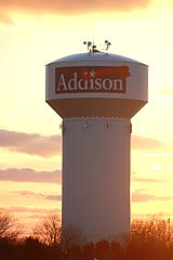
Addison (Illinois)
 | |
| Państwo | |
|---|---|
| Stan | |
| Hrabstwo | Hrabstwo DuPage |
| Burmistrz | Larry Hartwig |
| Powierzchnia | 24,6 km² |
| Populacja (2000) • liczba ludności • gęstość | 35 914 1470,5 os./km² |
| Kod pocztowy | 60101, 60114 |
| Strona internetowa | |
| Portal | |
Addison – wieś położona w hrabstwie DuPage, w stanie Illinois w Stanach Zjednoczonych na zachodzie zespołu miejskiego Chicago. Przez Addison przepływa rzeka Salt Creek.
Liczba ludności w 2000 r[1]. wynosiła 35914 mieszkańców, w 2002 roku[2] – 36378, a w 2006 – 37035[1].
Addison zostało założone w 1884 r. Nazwa wiąże się z nazwiskiem pisarza Josepha Addisona.
W miejscowości funkcjonował Adventureland – park rozrywki eksploatowany od 1961 r. do 1977 r. Był początkowo znany jako Paul’s Picnic Grove, a później jako Storybook Gardens. Od 1967 r. do 1976 r. był największym obiektem tego typu w stanie Illinois.
Wśród parków znajdujących się w miejscowości można wymienić: Wood Dale Grove County Forest Preserve, Farmwood Park, Nike Park, Oak Knoll Park, Oak Meadows County Forest Preserve, Cricket Creek County Forest Preserve, Community Park, Cherokee Park, Green Meadow Park.
W Addison znajduje się Muzeum Historyczne.
Edukacja
W Addison znajdują się dwie szkoły średnie: Addison Trail High School (publiczne), Driscoll Catholic High School (prywatne) oraz uczelnia wyższa: Devry Institute of Technology.
Gospodarka
Bezrobocie we wrześniu 2007 r. wynosiło: 4,4% (w stanie Illinois 4,8%). Średnia wielkość gospodarstwa domowego wynosi 3,1 os. (Illinois – 2,6 os.)[1].
Największym przedsiębiorstwem jest Minuteman International Inc (branża chłodnicza przemysł maszynowy)[1].
Centra handlowe: Farmwood Plaza Shopping Center, Lake Mill Plaza Shopping Center, Dominick's Shopping Center, Green Meadows Shopping Center, Centennial Plaza Shopping Center[1].
Znane osoby związane z miejscowością
- Tim Breslin – aktor;
- Mark Anelli – piłkarz;
- Leon Spinks – były mistrz boksu.
Przypisy
- ↑ a b c d e Addison, Illinois detailed profile, www.city-data.com (dostęp: 20 maja 2008)
- ↑ www.demographia.com
Media użyte na tej stronie
Autor: Uwe Dedering, Licencja: CC BY-SA 3.0
Location map of the USA (without Hawaii and Alaska).
EquiDistantConicProjection:
Central parallel:
* N: 37.0° N
Central meridian:
* E: 96.0° W
Standard parallels:
* 1: 32.0° N
* 2: 42.0° N
Made with Natural Earth. Free vector and raster map data @ naturalearthdata.com.
Formulas for x and y:
x = 50.0 + 124.03149777329222 * ((1.9694462586094064-({{{2}}}* pi / 180))
      * sin(0.6010514667026994 * ({{{3}}} + 96) * pi / 180))
y = 50.0 + 1.6155950752393982 * 124.03149777329222 * 0.02613325650382181
      - 1.6155950752393982  * 124.03149777329222 *
     (1.3236744353715044  - (1.9694462586094064-({{{2}}}* pi / 180))
      * cos(0.6010514667026994 * ({{{3}}} + 96) * pi / 180))
The flag of Navassa Island is simply the United States flag. It does not have a "local" flag or "unofficial" flag; it is an uninhabited island. The version with a profile view was based on Flags of the World and as a fictional design has no status warranting a place on any Wiki. It was made up by a random person with no connection to the island, it has never flown on the island, and it has never received any sort of recognition or validation by any authority. The person quoted on that page has no authority to bestow a flag, "unofficial" or otherwise, on the island.
Autor: Khateeb88, Licencja: CC BY-SA 3.0
The water tower of Addison, Illinois
Autor: Alexrk2, Licencja: CC BY 3.0
Ta mapa została stworzona za pomocą GeoTools.


