Adur (dystrykt)
| dystrykt niemetropolitalny | |
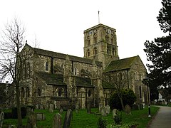
(c) Stuart Johnson, CC BY-SA 2.0 Shoreham-by-Sea | |
| Państwo | |
|---|---|
| Kraj | |
| Region | South East England |
| Hrabstwo | West Sussex |
| Siedziba | Shoreham-by-Sea |
| Powierzchnia | 41,80 km² |
| Populacja (2011) • liczba ludności | 61 300 |
| • gęstość | 1500 os./km² |
| Położenie na mapie West Sussex Contains Ordnance Survey data © Crown copyright and database right, CC BY-SA 3.0 | |
| Strona internetowa | |
| Portal | |
Adur – dystrykt w hrabstwie West Sussex w Anglii. Nazwa pochodzi od rzeki Adur.
Miasta
Inne miejscowości
Coombes, Kingston by Sea, Lancing, Sompting.
Media użyte na tej stronie
Flag of England. Saint George's cross (a red cross on a white background), used as the Flag of England, the Italian city of Genoa and various other places.
Contains Ordnance Survey data © Crown copyright and database right, CC BY-SA 3.0
Map of West Sussex, UK with Adur highlighted.
Equirectangular map projection on WGS 84 datum, with N/S stretched 155%(c) Stuart Johnson, CC BY-SA 2.0
St Mary de Haura, Shoreham-by-Sea Looking in a south-westerly direction


