Agarak (Lorri)
| ||
 | ||
| Państwo | ||
|---|---|---|
| Prowincja | Lorri | |
| Populacja (2011) • liczba ludności | 1155 | |
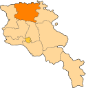
Położenie na mapie Armenii (c) Karte: NordNordWest, Lizenz: Creative Commons by-sa-3.0 de | ||
Agarak – wieś w Armenii, w prowincji Lorri. W 2011 roku liczyła 1155 mieszkańców.
Media użyte na tej stronie
Northern Lori from Pushkin Pass.jpg
The northern part of Armenia's northern province of Lori as seen from Pushkin Pass. Visible in this picture are the villages of Pushkino (foreground, left), Gargar (foreground, center), Gyulagarak (foreground, right), Lori Berd (background, center-left), Lejan (background, center-right), and Agarak (background, right). Panorama created with Hugin software.
The northern part of Armenia's northern province of Lori as seen from Pushkin Pass. Visible in this picture are the villages of Pushkino (foreground, left), Gargar (foreground, center), Gyulagarak (foreground, right), Lori Berd (background, center-left), Lejan (background, center-right), and Agarak (background, right). Panorama created with Hugin software.
Lori.svg
Autor:
Image shows the eleven administrative subdivisions of Armenia: # Aragatsotn (Արագածոտնի) # Ararat (Արարատի) # Armavir (Արմավիրի) # Gegharkunik (Գեղարքունիքի) # Kotayk (Կոտայքի) # Lori (Լոռու) # Shirak (Շիրակի) # Syunik (Սյունիքի) # Tavush (Տավուշի) # Vayots Dzor (Վայոց Ձորի) # Yerevan (Երևան) - special administrative status Derived from a multiple of public sources and created using Inkscape. ==
Autor:
- Armenia_map_numbered.svg: Bastique
- derivative work: Varmin (talk)
Image shows the eleven administrative subdivisions of Armenia: # Aragatsotn (Արագածոտնի) # Ararat (Արարատի) # Armavir (Արմավիրի) # Gegharkunik (Գեղարքունիքի) # Kotayk (Կոտայքի) # Lori (Լոռու) # Shirak (Շիրակի) # Syunik (Սյունիքի) # Tavush (Տավուշի) # Vayots Dzor (Վայոց Ձորի) # Yerevan (Երևան) - special administrative status Derived from a multiple of public sources and created using Inkscape. ==
Armenia adm location map.svg
(c) Karte: NordNordWest, Lizenz: Creative Commons by-sa-3.0 de
Location map of Armenia
(c) Karte: NordNordWest, Lizenz: Creative Commons by-sa-3.0 de
Location map of Armenia


