Aintree Motor Racing Circuit
| ||
 | ||
| Państwo | ||
| Lokalizacja | Aintree | |
| Długość | 4,828 km | |
| Główne imprezy | Formuła 1 | |
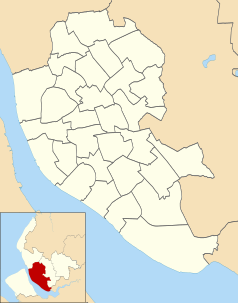
Położenie na mapie Liverpoolu Contains Ordnance Survey data © Crown copyright and database right, CC BY-SA 3.0 | ||
Położenie na mapie Wielkiej Brytanii (c) Karte: NordNordWest, Lizenz: Creative Commons by-sa-3.0 de | ||
Położenie na mapie Merseyside Contains Ordnance Survey data © Crown copyright and database right, CC BY-SA 3.0 | ||
Aintree Motor Racing Circuit – były tor Formuły 1 ulokowany w Aintree w Wielkiej Brytanii.
Zwycięzcy Grand Prix Wielkiej Brytanii na torze Aintree Motor Racing Circuit
| Sezon | Zwycięzca | Konstruktor | Wyniki |
|---|---|---|---|
| 1955 | |||
| 1957 | |||
| 1959 | |||
| 1961 | |||
| 1962 |
Zobacz też
Bibliografia
- Aintree (pol.). f1wm.pl. [dostęp 2011-07-27].
Media użyte na tej stronie
(c) Karte: NordNordWest, Lizenz: Creative Commons by-sa-3.0 de
Location map of the United Kingdom
Contains Ordnance Survey data © Crown copyright and database right, CC BY-SA 3.0
Map of Liverpool, Merseyside, UK with electoral wards shown.
Equirectangular map projection on WGS 84 datum, with N/S stretched 165%
Geographic limits:
- West: 3.02W
- East: 2.80W
- North: 53.48N
- South: 53.31N
Contains Ordnance Survey data © Crown copyright and database right, CC BY-SA 3.0
Map of Merseyside, UK with the following information shown:
- Administrative borders
- Coastline, lakes and rivers
- Roads and railways
- Urban areas
Equirectangular map projection on WGS 84 datum, with N/S stretched 165%
Geographic limits:
- West: 3.24W
- East: 2.54W
- North: 53.72N
- South: 53.27N
Circuit diagram of the Aintree track, England


