Akron (Ohio)
| ||||
| Państwo | ||||
|---|---|---|---|---|
| Stan | ||||
| Hrabstwo | ||||
| Data założenia | 1825 | |||
| Prawa miejskie | 1865 | |||
| Kod statystyczny | ||||
| Burmistrz | Dan Horrigan | |||
| Powierzchnia | 161,6 km² | |||
| Wysokość | 306 m n.p.m. | |||
| Populacja (2010) • liczba ludności |
| |||
| Nr kierunkowy | 330, 234 | |||
| Kod pocztowy | 44301–44399 | |||
| Strefa czasowa | ||||
Położenie na mapie Ohio  | ||||
Położenie na mapie Stanów Zjednoczonych  | ||||
| Strona internetowa | ||||
| Portal | ||||
Akron – miasto w Stanach Zjednoczonych w stanie Ohio, nad rzeką Cuyahoga. Zostało założone w 1807 roku.
W granicach miasta liczba mieszkańców wynosi 199 110, natomiast na obszarze metropolitalnym zameldowanych jest 701 456 osób. Północno-wschodni region stanu Ohio (zwany Northeast Ohio), składający się ze statystycznych obszarów metropolitalnych – Greater Cleveland, Akron, Canton–Massillon, Youngstown–Warren–Boardman, Mansfield i Sandusky – zamieszkuje 4 335 920 ludzi (2010).
Demografia
Gospodarka

Miasto znane jako „gumowa stolica świata”, w związku powstałymi w tym mieście licznymi przedsiębiorstwami produkującymi opony. W Akronie istnieje również przemysł chemiczny, lotniczy, elektrotechniczny i metalowy. Miejscowość przecinają dwie międzystanowe drogi.
Edukacja
Znajduje się tu Uniwersytet w Akronie i Akron Art Institute.
Sport
Nieistniejąca już drużyna futbolu amerykańskiego Akron Pros była w 1920 roku pierwszym mistrzem w historii NFL (zwanej wówczas APFA).
Miasta partnerskie
Osoby związane z miastem
- W Akronie urodził się Willard V. O. Quine, filozof analityczny i logik, określany jako „jeden z najbardziej wpływowych filozofów XX wieku”[2].
- W Akronie urodził się LeBron James, jeden z najlepszych koszykarzy świata.
- W mieście urodził się także koszykarz Nate Thurmond, członek Basketball Hall of Fame. Znalazł się on wśród 50 najlepszych graczy występujących kiedykolwiek w lidze NBA.
- Z Akronu pochodzi Stephen Curry, koszykarz, rozgrywający Golden State Warriors.
- Z tego miasta pochodzi również Jim Jarmusch, reżyser i muzyk.
Kościoły i związki wyznaniowe
Spis na 2010 rok, obejmuje aglomeracje miasta[3]:
- Kościół katolicki: 136 846 członków w 43 kościołach
- Protestantyzm bezdenominacyjny: 48 115 członków w 96 zborach
- Zjednoczony Kościół Metodystyczny: 24 701 członków w 56 zborach
- Kościoły Chrystusowe: 12 190 członków w 51 zborach
- Zjednoczony Kościół Chrystusa: 10 573 członków w 28 zborach
- Kościół Ewangelicko-Luterański w Ameryce: 6053 członków w 16 zborach
- Kościół Luterański Synodu Missouri: 5683 członków w 16 zborach
- Kościół episkopalny: 5411 członków w 12 zborach
- Chrześcijański i Misyjny Sojusz: 4298 członków w 15 zborach
- Zbory Boże: 3790 członków w 19 zborach
- Kościół Prezbiteriański USA: 3223 członków w 15 zborach
- Kościół Jezusa Chrystusa Świętych w Dniach Ostatnich: 2629 członków w 5 świątyniach
- Kościół Nazarejczyka: 2513 członków w 19 zborach
- Judaizm: 2410 wyznawców w 4 synagogach
- Amerykańskie Kościoły Baptystyczne w USA: 2399 członków w 9 zborach
- Kościół Boży (Anderson): 2204 członków w 12 zborach
- Islam: 2116 wyznawców w 3 meczetach
- Południowa Konwencja Baptystyczna: 2091 członków w 20 zborach
Galeria
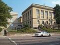
Budynek administracji hrabstwa Summit
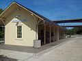
Stacja kolejowa „Northside” w Akron
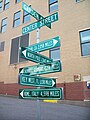
„Globalny” znak drogowy

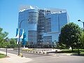
Centrum tranzytowe w Akron
Canal Park, stadium miejscowej drużyny bejsbolowej (2005)

Widok na centrum komercyjne Akron – Quaker Square (1979)

Centrala firmy oponiarskiej Goodyear

Centrum administracyjne Ocasek (mieści biura miejskie, stanowe i hrabstwa)
Budynek Polymer

Miejskie szpitale

Siedziba firmy GOJO
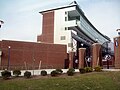
Stadium „Infocision” uniwersyteckiej drużyny futbolu amerykańskiego Akron Zips

Linki zewnętrzne
Przypisy
- ↑ Akron, Ohio Population Census 2010 and 2000. CensusViewer. [dostęp 2017-05-24]. (ang.).
- ↑ Christopher Lehmann-Haupt, W. V. Quine, Philosopher Who Analyzed Language and Reality, Dies at 92, „The New York Times”, 29 grudnia 2000, ISSN 0362-4331 [dostęp 2021-05-27] (ang.).
- ↑ thearda.com
Media użyte na tej stronie
Autor: Alexrk2, Licencja: CC BY 3.0
Ta mapa została stworzona za pomocą GeoTools.
Autor: Uwe Dedering, Licencja: CC BY-SA 3.0
Location map of the USA (without Hawaii and Alaska).
EquiDistantConicProjection:
Central parallel:
* N: 37.0° N
Central meridian:
* E: 96.0° W
Standard parallels:
* 1: 32.0° N
* 2: 42.0° N
Made with Natural Earth. Free vector and raster map data @ naturalearthdata.com.
Formulas for x and y:
x = 50.0 + 124.03149777329222 * ((1.9694462586094064-({{{2}}}* pi / 180))
      * sin(0.6010514667026994 * ({{{3}}} + 96) * pi / 180))
y = 50.0 + 1.6155950752393982 * 124.03149777329222 * 0.02613325650382181
      - 1.6155950752393982  * 124.03149777329222 *
     (1.3236744353715044  - (1.9694462586094064-({{{2}}}* pi / 180))
      * cos(0.6010514667026994 * ({{{3}}} + 96) * pi / 180))

Summit County Courthouse

Akron NorthSide Station, located in Akron, Ohio, United States.

(c) Threeblur0 at en.wikipedia, CC BY-SA 3.0
Chemnitz Germany
Akron Intermodal Transit Center, Akron, Ohio

(c) Rdikeman z angielskojęzycznej Wikipedii, CC-BY-SA-3.0
Canal Park, home of the Akron Aeros, AA Eastern League affiliate of the Cleveland Indians in 2005, by Rick Dikeman
22:13, 9 August 2005 . . Rdikeman . . 701×467 (86 KB)

Aerial view of the Akron factory of the Quaker Oats Company, located at 120 E. Mill Street in Akron, Ohio, United States. Built in 1825, it is listed on the National Register of Historic Places.

GoodYear, Akron Ohio.

Senator Oliver R. Ocasek Government Office Building in Akron, Ohio

Polymer Tower in Akron, Ohio, United States.


(c) Threeblur0 at en.wikipedia, CC BY-SA 3.0
Infocision Stadium at Summa Field


The flag of Navassa Island is simply the United States flag. It does not have a "local" flag or "unofficial" flag; it is an uninhabited island. The version with a profile view was based on Flags of the World and as a fictional design has no status warranting a place on any Wiki. It was made up by a random person with no connection to the island, it has never flown on the island, and it has never received any sort of recognition or validation by any authority. The person quoted on that page has no authority to bestow a flag, "unofficial" or otherwise, on the island.

Akron, Ohio


Flag of Israel. Shows a Magen David (“Shield of David”) between two stripes. The Shield of David is a traditional Jewish symbol. The stripes symbolize a Jewish prayer shawl (tallit).