Alamogordo (Nowy Meksyk)
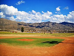
 Kompleks sportowy w Alamogordo | |
| Państwo | |
|---|---|
| Stan | Nowy Meksyk |
| Hrabstwo | |
| Data założenia | 1898 |
| Powierzchnia | 55,9 km² |
| Wysokość | 1320 m n.p.m. |
| Populacja (2020) • liczba ludności • gęstość |
|
| Nr kierunkowy | 575 |
| Kod pocztowy | 88310, 88311 |
| Strefa czasowa | |
| Strona internetowa | |
| Portal | |
Alamogordo – miasto na południu USA, w stanie Nowy Meksyk, na wysokości 1321 m n.p.m., na zachodnich stokach gór Sacramento, na południowy zachód od Albuquerque. Siedziba hrabstwa Otero. Według spisu w 2020 roku liczy 30,9 tys. mieszkańców i jest 10. co do wielkości miastem w stanie[1].
W odległości 24 km na południowy zachód znajduje się White Sands National Monument[2].
Historia
W pobliżu miasta leży baza Holloman Air Force Base w której na poligonie w dniu 16 lipca 1945 roku w ramach projektu Manhattan przeprowadzono pierwszą eksplozję bomby atomowej. Bomba eksplodowała z siłą 20 tysięcy ton trotylu, punkt zero, 30-metrowa wieża została przez Oppenheimera ochrzczona mianem Trinity. Po trzech tygodniach Amerykanie wykorzystali nową broń przeciwko Japonii (w Hiroszimie i Nagasaki).
Galeria
- (c) AudreyIski, CC BY-SA 3.0
Christ Community Church
Przypisy
- ↑ U.S. Census Bureau QuickFacts: Alamogordo city, New Mexico, www.census.gov [dostęp 2022-11-19] (ang.).
- ↑ Directions, White Sands. NPS. [dostęp 2014-05-23]. (ang.).
Media użyte na tej stronie
Autor: Alexrk2, Licencja: CC BY 3.0
Ta mapa została stworzona za pomocą GeoTools.
Autor: Uwe Dedering, Licencja: CC BY-SA 3.0
Location map of the USA (without Hawaii and Alaska).
EquiDistantConicProjection:
Central parallel:
* N: 37.0° N
Central meridian:
* E: 96.0° W
Standard parallels:
* 1: 32.0° N
* 2: 42.0° N
Made with Natural Earth. Free vector and raster map data @ naturalearthdata.com.
Formulas for x and y:
x = 50.0 + 124.03149777329222 * ((1.9694462586094064-({{{2}}}* pi / 180))
      * sin(0.6010514667026994 * ({{{3}}} + 96) * pi / 180))
y = 50.0 + 1.6155950752393982 * 124.03149777329222 * 0.02613325650382181
      - 1.6155950752393982  * 124.03149777329222 *
     (1.3236744353715044  - (1.9694462586094064-({{{2}}}* pi / 180))
      * cos(0.6010514667026994 * ({{{3}}} + 96) * pi / 180))
The flag of Navassa Island is simply the United States flag. It does not have a "local" flag or "unofficial" flag; it is an uninhabited island. The version with a profile view was based on Flags of the World and as a fictional design has no status warranting a place on any Wiki. It was made up by a random person with no connection to the island, it has never flown on the island, and it has never received any sort of recognition or validation by any authority. The person quoted on that page has no authority to bestow a flag, "unofficial" or otherwise, on the island.
entrance of Alameda Park Zoo in Alamogordo, New Mexico, showing the metal gate, the bridge over the duck pond, and the gift shop
Avis Building at the southwest corner of Tenth Street and New York Avenue in Alamogordo, New Mexico, with its distinctive onion (Byzantine) dome. The building dates to 1902 or 1903.
Autor: Foreverstocks, Licencja: CC BY-SA 4.0
Jim Griggs Sports Complex
David H. Townsend Library at New Mexico State University, Alamogordo campus.
New Mexico Museum of Space History, Alamogordo, New Mexico.
Alamogordo, New Mexico city hall building, located at 1376 E. 9th Street


