Alcedo (wulkan)
| ||
 Wulkan Alcedo | ||
| Państwo | ||
| Wysokość | 1130 m n.p.m. | |
| Dane wulkanu | ||
| Typ wulkanu | wulkan tarczowy | |
| Aktywność | wulkan czynny | |
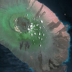
Alcedo – czynny wulkan tarczowy na wyspie Isabela w archipelagu Galapagos. Wznosi się na wysokość 1130 m n.p.m. Ostatnia erupcja miała miejsce w 1993 roku.
Opis
Alcedo położony jest wyspie Isabela w archipelagu Galapagos i jest najmniejszym z sześciu wulkanów na wyspie[1]. Kalderę (6 × 7 km[2]) i stoki pokrywa roślinność[1]. Zastygłe strumienie lawy znajdują się na północnym stoku[1]. Alcedo to jedyny wulkan na wyspach Galapagos wyrzucający oprócz lawy bazaltowej także ryolitową[1].
Alcedo był jedną z atrakcji turystycznych Parku Narodowego Galapagos do końca lat 90. XX wieku[3]. Żyje tu największa populacja żółwi słoniowych, która przetrwała pomimo inwazji osłów[3]. Jednak kiedy pod koniec lat 70. XX wieku kozy również dotarły do kaldery, środowisko żółwi zostało zagrożone[3]. W 2004 roku Park rozpoczął masową akcję usuwania gatunków introdukowanych, w tym osłów i kóz, która zakończyła się sukcesem w 2006 roku[3]. Alcedo pozostaje zamknięty dla turystów[3].
Erupcje
Erupcje miały miejsce w 1953 (z dokładnością do siedmiu lat) i 1993 roku[4]. Erupcja w 1954 roku była przypisywana Alcedo, ale najprawdopodobniej była to erupcja sąsiedniego wulkanu Sierra Negra[1]. Ostatni wybuch wulkanu miał miejsce w grudniu 1993 roku[4].
Zobacz też
Przypisy
- ↑ a b c d e Global Volcanism Program. Department of Mineral Sciences. National Museum of Natural History. Smithsonian Institution: Alcedo – General Information (ang.). 2016. [dostęp 2016-09-10].
- ↑ Terry Naumann, Dennis Geist, Mark Kurz. Petrology and Geochemistry of Volcán Cerro Azul: Petrologic Diversity among the Western Galápagos Volcanoes. „Journal of Petrology”. 5 (43), s. 859-883, 2002. DOI: 10.1093/petrology/43.5.859 (ang.).
- ↑ a b c d e Galapagos Conservancy: Isabela (ang.). W: Galapagos.org [on-line]. [dostęp 2016-09-10].
- ↑ a b Global Volcanism Program. Department of Mineral Sciences. National Museum of Natural History. Smithsonian Institution: Alcedo – Eruptive History (ang.). 2016. [dostęp 2016-09-10].
Media użyte na tej stronie
Made by author of Xramp, first uploaded by Denelson83 as Flag of Ecuador.svg, modifications by Husunqu.
Black up-pointing triangle ▲, U+25B2 from Unicode-Block Geometric Shapes (25A0–25FF)
Autor: Cnes - Spot Image, Licencja: CC BY-SA 3.0
Alcedo Volcano by SPOT Satellite
Autor: Uwe Dedering, Licencja: CC BY-SA 3.0
Relief location map of Pacific_Ocean.
- Projection: Lambert azimuthal equal-area projection.
- Area of interest:
- N: 60.0° N
- S: −80.0° N
- W: −260.0° E
- E: −70.0° E
- Projection center:
- NS: −10.0° N
- WE: −165.0° E
- GMT projection: -JA-165.0/-10.0/180/19.998266666666666c
- GMT region: -R-320.2519138145009/-12.459450078533589/-5.473602099069988/26.40516525873812r
- GMT region for grdcut: -R-325.0/-90.0/-5.0/74.0r
- Relief: SRTM30plus.
- Made with Natural Earth. Free vector and raster map data @ naturalearthdata.com.
Autor: NordNordWest, Licencja: CC BY 3.0
Location map of the Galápagos Islands, Ecuador
(Top left: P-43914; top right: P-43913; bottom left: P-43938;
bottom right: P-43939) These four images show varying three-dimensional perspectives of Isla Isabela — one of the chain of Galapagos Islands located in the eastern Pacific Ocean about 1,200 kilometers (750 miles) off the western coast of Ecuador in South America. The views were constructed by overlaying radar images from SIR-C/X-SAR on digital elevation maps produced by TOPSAR, a prototype airborne interferometric radar that produces simultaneous image and elevation data. The SIR-C/X-SAR images were obtained on April 10, 1994, during the 24th orbit of the space shuttle Endeavour (STS-59). Vertical exaggeration, about 1.87 times the actual relief, is used by scientists to detect relationships between structure (faults and fractures) and topography.
The Isla Isabela images are centered at about 0.5 degree south latitude and 91 degrees west longitude and cover an area of 75 by 60 kilometers (47 by 37 miles). The Galapagos Islands have six active volcanoes — similar to the volcanoes found in the Hawaiian Islands — and reflect the volcanic processes that occur where the ocean floor is created. The images show varying views of Alcedo (top left and right); Wolf, Darwin, and Alcedo (bottom left, from back); and Wolf and Darwin (bottom right, from back).
Since Charles Darwin's visit to the area in 1835, there have been more than 60 recorded eruptions on the Galapagos volcanoes. The images show the rougher lava flows as bright features, while ash deposits and smooth pahoehoe lava flows appear dark.


