Aldgate
| ||
 | ||
| Państwo | ||
| Miejscowość | Londyn | |
| Data otwarcia | 1878 | |
| Liczba peronów | 4 | |
| Circle Line | ||
| Poprzednia stacja | Liverpool Street | |
| Następna stacja | Tower Hill | |
| Metropolitan Line | ||
| Poprzednia stacja | Liverpool Street | |
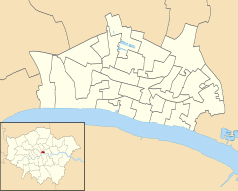
Położenie na mapie City of London Contains Ordnance Survey data © Crown copyright and database right, CC BY-SA 3.0 | ||
Położenie na mapie Wielkiej Brytanii (c) Karte: NordNordWest, Lizenz: Creative Commons by-sa-3.0 de | ||
Położenie na mapie Wielkiego Londynu Contains Ordnance Survey data © Crown copyright and database right, CC BY-SA 3.0 | ||
| Portal | ||
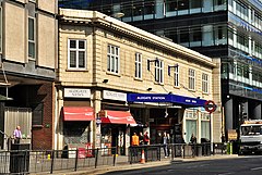
Aldgate – stacja londyńskiego metra położona w City of London, w pierwszej strefie biletowej. Stacja znajduje się na trasie linii Circle, pomiędzy stacjami Tower Hill a Liverpool Street, a także jest stacją końcową linii Metropolitan na jej wschodnim końcu.
W 2011 roku stacja obsłużyła 6,24 miliona pasażerów[1].
Stacja Aldgate została otwarta 18 listopada 1876 roku[2]. Początkowo istniało połączenie z Aldgate do Richmond oraz do Hammersmith. Od 1941 roku Aldgate jest stacją końcową dla Metropolitan Line, wcześniej istniało połączenie na południe przez nieistniącą już linię East London Line (obecnie część London Overground).
7 lipca 2005 roku, w czasie zamachów bombowych w londyńskim metrze, zamachowiec Shehzad Tanweer zdetonował bombę w pociągu linii Circle, który wyjechał z Liverpool Street i zbliżał się do stacji Aldgate, zabijając 7 osób i raniąc ponad 100[3]. Spośród wszystkich stacji, w pobliżu których dokonano zamachów, Aldgate była pierwszą, która wznowiła działalność[4].
Połączenia
Stacja Aldgate znajduje się w niewielkiej odległości od stacji kolejowej Fenchurch Street, obsługiwanej przez przewoźnika c2c. W pobliżu zatrzymują się autobusy linii: 15, 25, 40, 42, 67, 78, 100, 115, 135, 205, 254 oraz nocne: N15, N253, 550 i 551.
Galeria
Przypisy
- ↑ Customer metrics: entries and exits (ang.). Transport For London. [dostęp 2012-05-23].
- ↑ Aldgate Station (ang.). English Heritage. [dostęp 2012-05-23].
- ↑ Profile: Shehzad Tanweer (ang.). BBC News. [dostęp 2012-05-23].
- ↑ Terror Blasts: Aldgate Tube Reopens (ang.). Sky News, 25.07.2005. [dostęp 2012-05-23].
| |||||||||||
| |||||||||||||||||
Media użyte na tej stronie
(c) Karte: NordNordWest, Lizenz: Creative Commons by-sa-3.0 de
Location map of the United Kingdom
Autor: Sunil060902, Licencja: CC BY-SA 3.0
Aldgate tube station platform 2 (terminating Metropolitan line) looking north, with a train of A Stock awaiting departure in adjacent platform 3.
Autor: Sunil060902, Licencja: CC BY-SA 3.0
Aldgate tube station platform 4 (anticlockwise Circle line) and 3 (one of two Metropolitan terminating platforms) looking north from footbridge
Contains Ordnance Survey data © Crown copyright and database right, CC BY-SA 3.0
Map of Greater London, UK with the following information shown:
- Administrative borders
- Coastline, lakes and rivers
- Roads and railways
- Urban areas
The data includes both primary routes and railway lines.
Equirectangular map projection on WGS 84 datum, with N/S stretched 160%
Geographic limits:
- West: 0.57W
- East: 0.37E
- North: 51.72N
- South: 51.25N
Autor: Eluveitie, Licencja: CC BY-SA 3.0
Aldgate underground station, London
Autor: Sunil060902, Licencja: CC BY-SA 3.0
Aldgate tube station platform 1 (clockwise Circle line) looking north
Contains Ordnance Survey data © Crown copyright and database right, CC BY-SA 3.0
Blank map of the City of London, showing electoral wards.
Equirectangular map projection on WGS 84 datum, with N/S stretched 160%
Geographic limits:
- West: 0.12W
- East: 0.07W
- North: 51.525N
- South: 51.5N
Autor: Sunil060902, Licencja: CC BY-SA 3.0
Aldgate station platform roundel


