Alperton (stacja metra)
 Budynek stacji | |
| Państwo | |
|---|---|
| Data otwarcia | 1903 |
| Piccadilly line | |
| Poprzednia stacja | Park Royal |
| Następna stacja | Sudbury Town |
Położenie na mapie gminy Brent  Contains Ordnance Survey data © Crown copyright and database right, CC BY-SA 3.0 | |
Położenie na mapie Wielkiej Brytanii  (c) Karte: NordNordWest, Lizenz: Creative Commons by-sa-3.0 de | |
Położenie na mapie Anglii  | |
Położenie na mapie Wielkiego Londynu  Contains Ordnance Survey data © Crown copyright and database right, CC BY-SA 3.0 | |
| Portal | |
Alperton – naziemna stacja metra londyńskiego na terenie London Borough of Brent. Została otwarta w 1903 pod nazwą Perivale Alperton jako część District Line. W 1910 uzyskała obecną nazwę[1], zaś w 1932 weszła w skład Piccadilly line, do której przynależy do dziś[2]. W roku 2009 skorzystało z niej ok. 3,04 mln pasażerów[3]. Należy do czwartej strefy biletowej[4].
Galeria

Logo stacji
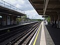
Perony
Przypisy
- ↑ CULG - District Line. [dostęp 2011-05-21].
- ↑ CULG - Piccadilly Line. [dostęp 2011-05-21].
- ↑ Statystyki Transport for London [dostęp 2011-05-21]
- ↑ Lista stacji i stref biletowych metra londyńskiego [dostęp 2011-05-21]
| Linia główna |
|
|---|---|
| Odgałęzienie Uxbridge |
|
| Odgałęzienie Heathrow |
|
![]()
| Metro | |
|---|---|
| London Overground | |
| Chiltern Railways |
|
Media użyte na tej stronie
(c) Karte: NordNordWest, Lizenz: Creative Commons by-sa-3.0 de
Location map of the United Kingdom
Contains Ordnance Survey data © Crown copyright and database right, CC BY-SA 3.0
Map of Greater London, UK with the following information shown:
- Administrative borders
- Coastline, lakes and rivers
- Roads and railways
- Urban areas
The data includes both primary routes and railway lines.
Equirectangular map projection on WGS 84 datum, with N/S stretched 160%
Geographic limits:
- West: 0.57W
- East: 0.37E
- North: 51.72N
- South: 51.25N


Autor: Sunil060902, Licencja: CC BY-SA 3.0
Alperton tube station looking westbound (actually north here)

Autor: Sunil060902, Licencja: CC BY-SA 3.0
Alperton tube station platform roundel


Autor: Sunil060902, Licencja: CC BY-SA 3.0
Alperton tube station building
Contains Ordnance Survey data © Crown copyright and database right, CC BY-SA 3.0
Blank map of the London Borough of Brent, showing electoral wards.
Equirectangular map projection on WGS 84 datum, with N/S stretched 160%
Geographic limits:
- West: 0.34W
- East: 0.18W
- North: 51.605N
- South: 51.525N