Alummot
| ||
(c) Hanay, CC BY-SA 3.0 | ||
| Państwo | ||
| Dystrykt | Północny | |
| Populacja • liczba ludności | 241 | |
| Portal | ||
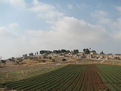
Alummot (hebr. אלומות) - kibuc położony w samorządzie regionu Emek ha-Jarden, w Dystrykcie Północnym, w Izraelu.
Leży na południe od Jeziora Tyberiadzkiego w Dolnej Galilei.
Członek Ruchu Kibuców (Ha-Tenu’a ha-Kibbucit).
Historia
Kibuc został założony w 1947.
Gospodarka
Gospodarka kibucu opiera się na intensywnym rolnictwie.
Linki zewnętrzne
Media użyte na tej stronie
Autor: NordNordWest, Licencja: CC BY-SA 3.0
Flag of Israel. Shows a Magen David (“Shield of David”) between two stripes. The Shield of David is a traditional Jewish symbol. The stripes symbolize a Jewish prayer shawl (tallit).
(c) Hanay, CC BY-SA 3.0
Alummot is a kibbutz in northern Israel. Located to the south of the Sea of Galileeץ
אלומות הוא קיבוץ היושב על גבעה הצופה על הכנרת ויישובי עמק הירדן. הוא שייך למועצה אזורית עמק הירדן.


