Alwar (miasto)
 | |
| Państwo | |
|---|---|
| Stan | Radżastan |
| Dystrykt | Alwar |
| Populacja (2011) • liczba ludności | 315 310 |
| Nr kierunkowy | 144 |
| Kod pocztowy | 301001 |
Położenie na mapie Indii | |
| Strona internetowa | |
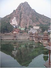
Alwar (hindi अलवर) – miasto w północno-zachodnich Indiach, w stanie Radżastan. Znajduje się około 160 km na południe od Delhi i około 150 km na północ od Jaipur. 10 maja 1956 roku w Alwar odnotowano najwyższą temperaturę w historii Indii 50,6 °C[1]. Liczy ok. 315 tys. mieszkańców[2].
Alwar jest bogate w bogactwa mineralne. Produkuje się głównie: marmur, granit, skaleń, dolomit, kwarc, kamień wapienny, mydła, kamień i ruda miedzi[3].
Przypisy
- ↑ Extreme Weather Events. [dostęp 2013-01-16]. [zarchiwizowane z tego adresu (2016-03-04)].
- ↑ Spis powszechny Indii. [dostęp 2019-07-11]. [zarchiwizowane z tego adresu (2019-07-11)].
- ↑ Mineral Resources. [dostęp 2013-01-16]. [zarchiwizowane z tego adresu (2014-06-19)].
Media użyte na tej stronie
(c) Uwe Dedering z niemieckiej Wikipedii, CC BY-SA 3.0
Location map of India.
Equirectangular projection. Strechted by 106.0%. Geographic limits of the map:
- N: 37.5° N
- S: 5.0° N
- W: 67.0° E
- E: 99.0° E
The Flag of India. The colours are saffron, white and green. The navy blue wheel in the center of the flag has a diameter approximately the width of the white band and is called Ashoka's Dharma Chakra, with 24 spokes (after Ashoka, the Great). Each spoke depicts one hour of the day, portraying the prevalence of righteousness all 24 hours of it.
Autor: User:Deepak, Licencja: CC-BY-SA-3.0
A pond in Alwar, Rajasthan. The snap shown is of artificial pond called "Sagar" which is present behind the collectorate of Alwar. It was built by the Naruka Maharajas of Alwar. In the same complex are situated : Musi Maharani Ki Chhatari (Cenoteph of Queen Musi), Alwar Museum and Alwar collectorate which houses many government offices.
Autor: Autor nie został podany w rozpoznawalny automatycznie sposób. Założono, że to Miljoshi (w oparciu o szablon praw autorskich)., Licencja: CC-BY-SA-3.0
Blank - Map of w:Rajasthan state, India with district boundaries.


