Amarillo
| ||||
 Śródmieście Amarillo w 2018 roku. | ||||
| Państwo | ||||
|---|---|---|---|---|
| Stan | ||||
| Hrabstwo | ||||
| Kod statystyczny | ||||
| Burmistrz | Ginger Nelson | |||
| Powierzchnia | 269 km² | |||
| Wysokość | 1099 m n.p.m. | |||
| Populacja (2020) • liczba ludności • gęstość |
| |||
| Nr kierunkowy | 806 | |||
| Kod pocztowy | 79101-79111, 79114, 79116-79121, 79123-79124, 79159, 79163, 79166-79168, 79171-79172, 79174, 79178, 79182, 79185, 79187, 79189 | |||
| Strefa czasowa | ||||
Położenie na mapie Teksasu  | ||||
Położenie na mapie Stanów Zjednoczonych  | ||||
| Strona internetowa | ||||
| Portal | ||||
Amarillo – miasto w Stanach Zjednoczonych, w regionie Llano Estacado, w północno-zachodniej części Teksasu. Według spisu z 2020 roku przekroczyło liczbę 200 tys. mieszkańców i jest 15-tym co do wielkości miastem w stanie[1][2].

Dane ogólne
Ośrodek wydobycia ropy naftowej i gazu ziemnego, pozyskiwania helu; przemysł petrochemiczny, zbrojeniowy (do niedawna montaż głowic atomowych), środków transportu, spożywczy (produkcja mięsa wołowego). Ważny węzeł komunikacyjny.
Historia
Miasto, początkowo nazywane Oneida, powstało w 1887 roku jako obóz budowy kolei, a w latach 90. XIX wieku stało się jednym z najbardziej ruchliwych ośrodków transportu bydła na świecie. Jego znaczenie wzrosło po 1900 r., kiedy w regionie rozwinęły się uprawa pszenicy i hodowla. Odkrycie złóż ropy naftowej i gazu ziemnego w latach dwudziestych XX w. sprzyjało rozwojowi przemysłu[3].
Demografia
Rasy i pochodzenie
W 2019 roku 81,4% mieszkańców stanowi ludność biała (53,0% nie licząc Latynosów), 7,2% to czarni lub Afroamerykanie, 5,2% to Azjaci, 2,6% ma rasę mieszaną, 0,6% to rdzenna ludność Ameryki i 0,23% to Hawajczycy i mieszkańcy innych wysp Pacyfiku. Latynosi stanowią 34% ludności miasta[4].
Do największych grup należą osoby pochodzenia meksykańskiego (28,7%), niemieckiego (8,3%), angielskiego (7,7%), irlandzkiego (6,8%) i „amerykańskiego” (5,4%). Polacy stanowili 0,9% populacji miasta[5].
Religia

Amarillo jest najbardziej ewangelikalnym miastem w stanie, wśród miast liczących ponad 100 tys. mieszkańców. W 2010 roku połowa populacji metropolii (125,2 tys. – 49,7%) jest członkami Kościołów ewangelikalnych, w większości baptystycznych, ale także bezdenominacyjnych (18,8 tys.), campbellitów (8,6 tys.), czy zielonoświątkowych (4,9 tys.)[6]. Do innych większych grup religijnych w aglomeracji Amarillo należą[7]:
- Kościół katolicki – 18 293 członków w 16 kościołach,
- protestanci głównego nurtu (głównie Zjednoczony Kościół Metodystyczny) – 16 070 członków,
- muzułmanie – 5084 wyznawców,
- mormoni – 3052 członków,
- czarni protestanci (głównie Kościół Boży w Chrystusie) – 1929 członków,
- buddyści – 1348 wyznawców,
- świadkowie Jehowy – 4 zbory.
Galeria

Centrum Amarillo

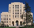
Budynek Sądu Okręgowego
Siedziba sądu hrabstwa Potter

Słynna restauracja i motel Big Texan Steak Ranch

Kościół metodystyczny

Muzeum związane z końmi

Centrum Sztuk Widowiskowych

Ceglana ulica
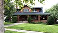
Shelton-Houghton House
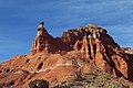
Komin skalny kanionu Palo Duro, położony 20 km na południowy wschód od Amarillo
Urodzeni w Amarillo
- Cyd Charisse (1922–2008) – aktorka i tancerka[8]
- Joe Ely (ur. 1947) – piosenkarz i gitarzysta
- Carolyn Jones (1930–1983) – aktorka
- George Saunders (ur. 1958) – pisarz
- Jimmie Dale Gilmore (ur. 1945) – piosenkarz country
- Ann Doran (1911–2000) – aktorka
- Bascom N. Timmons (1890–1987) – dziennikarz, doradca prezydentów
- Rick Husband (1957–2003) – astronauta i pilot myśliwca
- Jack Wrather (1918–1984) – przedsiębiorca i biznesmen naftowy
Przypisy
- ↑ U.S. Census Bureau QuickFacts: Amarillo city, Texas, www.census.gov [dostęp 2021-12-16] (ang.).
- ↑ Biggest Cities in Texas - 2020 Population Data, www.biggestuscities.com [dostęp 2021-06-04].
- ↑ Amarillo, [w:] Encyclopædia Britannica [online] [dostęp 2021-06-05] (ang.).
- ↑ 2019: ACS 1-Year Estimates Data Profiles – DP05, data.census.gov [dostęp 2021-06-05].
- ↑ 2019: ACS 1-Year Estimates Detailed Tables – TableID: DP02, data.census.gov [dostęp 2021-06-05].
- ↑ Evangelical Protestant Metro Areas (2010) - QuickLists, www.thearda.com [dostęp 2021-06-04].
- ↑ Amarillo, TX, Metropolitan Statistical Area - Religious Traditions, 2010, www.thearda.com [dostęp 2021-06-04].
- ↑ Famous People From Amarillo, Texas - #1 is Cyd Charisse, Playback.fm [dostęp 2021-06-05] (ang.).
Media użyte na tej stronie
Autor: Uwe Dedering, Licencja: CC BY-SA 3.0
Location map of the USA (without Hawaii and Alaska).
EquiDistantConicProjection:
Central parallel:
* N: 37.0° N
Central meridian:
* E: 96.0° W
Standard parallels:
* 1: 32.0° N
* 2: 42.0° N
Made with Natural Earth. Free vector and raster map data @ naturalearthdata.com.
Formulas for x and y:
x = 50.0 + 124.03149777329222 * ((1.9694462586094064-({{{2}}}* pi / 180))
      * sin(0.6010514667026994 * ({{{3}}} + 96) * pi / 180))
y = 50.0 + 1.6155950752393982 * 124.03149777329222 * 0.02613325650382181
      - 1.6155950752393982  * 124.03149777329222 *
     (1.3236744353715044  - (1.9694462586094064-({{{2}}}* pi / 180))
      * cos(0.6010514667026994 * ({{{3}}} + 96) * pi / 180))

The flag of Navassa Island is simply the United States flag. It does not have a "local" flag or "unofficial" flag; it is an uninhabited island. The version with a profile view was based on Flags of the World and as a fictional design has no status warranting a place on any Wiki. It was made up by a random person with no connection to the island, it has never flown on the island, and it has never received any sort of recognition or validation by any authority. The person quoted on that page has no authority to bestow a flag, "unofficial" or otherwise, on the island.

Autor: Who What Where Nguyen Why, Licencja: CC-BY-SA-3.0
The Potter Courthouse building in downtown Amarillo, Texas, U.S.A. This courthouse lies along Fillmore St. once signed as Route 66. The building was added to the National Register of Historic Places on August 22, 1996.

Autor: Autor nie został podany w rozpoznawalny automatycznie sposób. Założono, że to J. Nguyen~commonswiki (w oparciu o szablon praw autorskich)., Licencja: CC-BY-SA-3.0
Outside of the American Quarter Horse Association's Heritage Center and Museum in Amarillo, Texas. The photograph was taken on January 27, 2006 by the uploader.
Autor: Alexrk, Licencja: CC BY 3.0
Ta mapa została stworzona za pomocą GeoTools.
Autor: Chris Hale (photographer), Licencja: CC BY-SA 4.0
This is a shot of the Amarillo skyline (FirstBank Southwest Tower, Amarillo National Bank, Happy State Bank, Maxor, and the rolling hills of the plains).


Autor: BriceWi999, Licencja: CC BY-SA 3.0
Shelton-Houghton House, 1700 Polk St. Amarillo

Autor: Mathieu BROSSAIS, Licencja: CC BY-SA 4.0
Façade du restaurant The Big Texan à Amarillo

Autor: BriceWi999, Licencja: CC BY-SA 3.0
Polk Street Methodist Church, 1401 S. Polk St. Amarillo

Autor: Who What Where Nguyen Why, Licencja: CC-BY-SA-3.0
The Potter District Courts building in downtown Amarillo, Texas, U.S.A.

Autor: Autor nie został podany w rozpoznawalny automatycznie sposób. Założono, że to Who What Where Nguyen Why~commonswiki (w oparciu o szablon praw autorskich)., Licencja: CC-BY-SA-3.0
The Globe-News Center in Amarillo, Texas, USA. Globe-News Center of the Performing Arts building located next to the city's downtown library.
Photo taken on April 14, 2006 by the uploader.Autor: Who What Where Nguyen Why a/k/a Anonymous Cow, Licencja: CC-BY-SA-3.0
The Amarillo Museum of Art building in Amarillo, Texas, U.S.A.

Autor: Clinton Steeds from Los Angeles, USA, Licencja: CC BY 2.0
Capitol Peak with pillar-like erosional remnant (“hoodoo”) at the tip of its southern promontory, seen from a hiking trail at the southern foot of the mountain, northern part of Palo Duro Canyon, about 20 km SE of Amarillo, NW-Texas, USA. The terrestrial red beds exposed at Capitol Peak belong to the Quartermaster Formation of the Upper Permian, overlain by the Tecovas Formation of the Dockum Group of the Upper Triassic.[1] Both formations are easily distiguished from each other by their colouration: The beds of the Quartermaster Formation are more yellowish, whereas those of the Tecovas Formation are more bluish.

Autor: Who What Where Nguyen Why a/k/a Anonymous Cow, Licencja: CC-BY-SA-3.0
A shot of downtown Amarillo, Texas, U.S.A.

Uploaded just to display the brick streets in Amarillo, Texas. The photo was quickly taken by the uploader.
View is from E 8th Ave looking east toward S Fillmore St.Autor: Halle hebbel, Licencja: CC BY-SA 4.0
Worship on Easter Sunday 2018 at Trinity Fellowship Church, Amarillo, Texas