Ambala
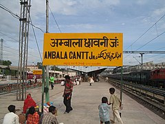
(c) - Credit to Gopal Aggarwal with link http://gopal1035.blogspot.com (thanks!), CC BY 2.5 Perony stacji kolejowej w Ambali | |
| Państwo | |
|---|---|
| Stan | |
| Dystrykt | Ambala |
| Populacja (2003) • liczba ludności |
|
| Nr kierunkowy | 0171 |
Położenie na mapie Indii | |
Ambala (hindi अम्बाला) – miasto w Indiach (Hariana), na północ od Delhi.
Liczba mieszkańców w 2011 wynosiła 1 128 350[1]; dla porównania, w 1971 było to 102,5 tys.[2]
Przemysł spożywczy, bawełniany, szklarski i papierniczy. Węzeł kolejowy i drogowy[2].
Przypisy
- ↑ CrnsusInfo India 2011. devinfo.org. [dostęp 2014-05-31].
- ↑ a b Encyklopedia Powszechna PWN. T. 1. A-F. Warszawa: Państwowe Wydawnictwo Naukowe, 1974, s. 71.
Media użyte na tej stronie
(c) Uwe Dedering z niemieckiej Wikipedii, CC BY-SA 3.0
Location map of India.
Equirectangular projection. Strechted by 106.0%. Geographic limits of the map:
- N: 37.5° N
- S: 5.0° N
- W: 67.0° E
- E: 99.0° E
The Flag of India. The colours are saffron, white and green. The navy blue wheel in the center of the flag has a diameter approximately the width of the white band and is called Ashoka's Dharma Chakra, with 24 spokes (after Ashoka, the Great). Each spoke depicts one hour of the day, portraying the prevalence of righteousness all 24 hours of it.
Autor:
- Haryana_locator_map.svg: by User:Planemad
- derivative work: User:Milenioscuro
Location map of Haryana Geographic limits of the map:
- 31.01°N
- 27.59°N
- 74.39°E
- 77.61°E
(c) - Credit to Gopal Aggarwal with link http://gopal1035.blogspot.com (thanks!), CC BY 2.5
Ambala (Hindi: अंबाला) is a city located on the border of the states of Haryana and Punjab in India. Politically; Ambala has two sub-areas: Ambala Cantt (cantonment) and Ambala City, a few kilometers apart from each other.
The Cantonment's railway station board


