Amsterdam (Missouri)
| ||||
| Państwo | ||||
|---|---|---|---|---|
| Stan | ||||
| Hrabstwo | Bates | |||
| Kod statystyczny | FIPS: 29-01090 GNIS ID: 0729836[1] | |||
| Powierzchnia | 1,5 km² | |||
| Wysokość | 270[1] m n.p.m. | |||
| Populacja (2010[2]) • liczba ludności • gęstość | 242 185,7 os./km² | |||
| Nr kierunkowy | 660 | |||
| Kod pocztowy | 64723 | |||
| Strefa czasowa | UTC-06:00 UTC-05:00 | |||
| Portal | ||||
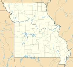
Amsterdam – miasto w Stanach Zjednoczonych, w zachodniej części stanu Missouri. Liczba mieszkańców w 2000 roku wynosiła 281[2].
Historia miasta
Amsterdam został założony w 1891 r.[3] Nazwa miasta pochodzi od Amsterdamu, czyli stolicy Holandii[4][5] Arthur Stilwell, dyrektor kolei z początku XX w., wybrał to miasto, ponieważ w stolicy Holandii znajdowała się firma ważnego finansisty kolejowego, Jana de Goeijen[5]. Od 1892 r. w Amsterdamie działa poczta[6].
Przypisy
- ↑ a b Feature Detail Report for: Amsterdam, Missouri (ang.). The Geographic Names Information System (GNIS). [dostęp 2018-03-02].
- ↑ a b Amsterdam, Missouri Population Census 2010 and 2000 (ang.). CensusViewer. [dostęp 2018-03-02].
- ↑ Bates County, Missouri Place Names, 1928-1945 | The State Historical Society of Missouri, web.archive.org, 24 czerwca 2016 [dostęp 2021-10-23] [zarchiwizowane z adresu 2016-06-24].
- ↑ David W. (David Wolfe) Eaton, How Missouri counties, towns and streams were named .., Columbia, Mo., The State historical society, 1916 [dostęp 2021-10-23].
- ↑ a b The Nevada Daily Mail – Wyszukiwanie w archiwum Wiadomości Google, news.google.com [dostęp 2021-10-23].
- ↑ Notification Service | Post Offices, www.postalhistory.com [dostęp 2021-10-23].
Media użyte na tej stronie
Autor: Uwe Dedering, Licencja: CC BY-SA 3.0
Location map of the USA (without Hawaii and Alaska).
EquiDistantConicProjection:
Central parallel:
* N: 37.0° N
Central meridian:
* E: 96.0° W
Standard parallels:
* 1: 32.0° N
* 2: 42.0° N
Made with Natural Earth. Free vector and raster map data @ naturalearthdata.com.
Formulas for x and y:
x = 50.0 + 124.03149777329222 * ((1.9694462586094064-({{{2}}}* pi / 180))
      * sin(0.6010514667026994 * ({{{3}}} + 96) * pi / 180))
y = 50.0 + 1.6155950752393982 * 124.03149777329222 * 0.02613325650382181
      - 1.6155950752393982  * 124.03149777329222 *
     (1.3236744353715044  - (1.9694462586094064-({{{2}}}* pi / 180))
      * cos(0.6010514667026994 * ({{{3}}} + 96) * pi / 180))
The flag of Navassa Island is simply the United States flag. It does not have a "local" flag or "unofficial" flag; it is an uninhabited island. The version with a profile view was based on Flags of the World and as a fictional design has no status warranting a place on any Wiki. It was made up by a random person with no connection to the island, it has never flown on the island, and it has never received any sort of recognition or validation by any authority. The person quoted on that page has no authority to bestow a flag, "unofficial" or otherwise, on the island.
Autor: Alexrk2, Licencja: CC BY 3.0
Ta mapa została stworzona za pomocą GeoTools.


