Anacapa
 West Anacapa | |
| Kontynent | |
|---|---|
| Państwo | |
| Akwen | |
| Archipelag | |
| Powierzchnia | 2,947 km² |
| Populacja • liczba ludności |
|
Położenie na mapie Kalifornii  | |
Położenie na mapie Stanów Zjednoczonych  | |
Anacapa – grupa 3 wulkanicznych wysp leżąca 23 km od wybrzeża hrabstwa Ventura w Kalifornii. Anacapa jest częścią archipelagu i częścią wysp Parku narodowego Channel Islands. Składa się z trzech wysp: East Island, Middle Island i West Island. Nazwa Anacapa wywodzi się od słowa eneepah z języka Indian Chumash (ang. mirage island)[1].
Katastrofy
- W nocy 2 grudnia 1853 r. parowiec SS Winfield Scott zatonął u wybrzeży wyspy. Wszyscy ocaleni zostali odnalezieniu po tygodniu.
- 31 stycznia 2000 Alaska Airlines 261 lecący z Puerto Vallarta do San Francisco, rozbił się w wyniku uszkodzenia stateczników poziomych. Śmierć poniosło 88 osób.
Latarnia morska – zdjęcie lotnicze
Latarnia morska Anacapa Island

Widok z lotu ptaka na Anacapa Island

Zdjęcie satelitarne wysp
Linki zewnętrzne
Przypisy
- ↑ Erwin G. Gudde: California Place Names: The Origin and Etymology of Current Geographical Names. University of California Press, 2004-05-10, s. 12. ISBN 0-520-24217-3.

| Wyspy północne |
|
|---|---|
| Wyspy południowe |
|

Media użyte na tej stronie
Usa edcp relief location map.png
Autor: Uwe Dedering, Licencja: CC BY-SA 3.0
Relief location map of the USA (without Hawaii and Alaska).
Autor: Uwe Dedering, Licencja: CC BY-SA 3.0
Relief location map of the USA (without Hawaii and Alaska).
EquiDistantConicProjection : Central parallel :
* N: 37.0° N
Central meridian :
* E: 96.0° W
Standard parallels:
* 1: 32.0° N
* 2: 42.0° N
Made with Natural Earth. Free vector and raster map data @ naturalearthdata.com.
Formulas for x and y:
x = 50.0 + 124.03149777329222 * ((1.9694462586094064-({{{2}}}* pi / 180))
      * sin(0.6010514667026994 * ({{{3}}} + 96) * pi / 180))
y = 50.0 + 1.6155950752393982 * 124.03149777329222 * 0.02613325650382181
      - 1.6155950752393982  * 124.03149777329222 *
     (1.3236744353715044  - (1.9694462586094064-({{{2}}}* pi / 180))
      * cos(0.6010514667026994 * ({{{3}}} + 96) * pi / 180))

Flag of the United States.svg
The flag of Navassa Island is simply the United States flag. It does not have a "local" flag or "unofficial" flag; it is an uninhabited island. The version with a profile view was based on Flags of the World and as a fictional design has no status warranting a place on any Wiki. It was made up by a random person with no connection to the island, it has never flown on the island, and it has never received any sort of recognition or validation by any authority. The person quoted on that page has no authority to bestow a flag, "unofficial" or otherwise, on the island.
The flag of Navassa Island is simply the United States flag. It does not have a "local" flag or "unofficial" flag; it is an uninhabited island. The version with a profile view was based on Flags of the World and as a fictional design has no status warranting a place on any Wiki. It was made up by a random person with no connection to the island, it has never flown on the island, and it has never received any sort of recognition or validation by any authority. The person quoted on that page has no authority to bestow a flag, "unofficial" or otherwise, on the island.

Flag of California.svg
Flag of California. This version is designed to accurately depict the standard print of the bear as well as adhere to the official flag code regarding the size, position and proportion of the bear, the colors of the flag, and the position and size of the star.
Flag of California. This version is designed to accurately depict the standard print of the bear as well as adhere to the official flag code regarding the size, position and proportion of the bear, the colors of the flag, and the position and size of the star.

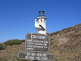
Anacapa lighthouse.jpg
(c) Infernalfox at the English Wikipedia, CC-BY-SA-3.0
Seagulls dominate the island's sparse wildlife.
(c) Infernalfox at the English Wikipedia, CC-BY-SA-3.0
Seagulls dominate the island's sparse wildlife.

Aerial-AnacapaLight.jpg
Autor: John Wiley User:Jw4nvc - Santa Barbara, California, Licencja: CC BY 3.0
Aerial photo: Anacapa Island Lighthouse in the Santa Barbara Channel Islands, California.
Autor: John Wiley User:Jw4nvc - Santa Barbara, California, Licencja: CC BY 3.0
Aerial photo: Anacapa Island Lighthouse in the Santa Barbara Channel Islands, California.

Anacapa Aerial NOAA.jpg
Aerial view of Anacapa Island, Channel Islands, California
Aerial view of Anacapa Island, Channel Islands, California
Californian Channel Islands map en.png
Autor: Lencer, Licencja: CC BY-SA 3.0
Map of the Channel Islands archipelago — in Southern California.
Autor: Lencer, Licencja: CC BY-SA 3.0
Map of the Channel Islands archipelago — in Southern California.
- The northern islands (dark green) are protected within Channel Islands National Park.
- The marine ecosystem around the northern islands and Santa Barbara Island is protected within the Channel Islands National Marine Sanctuary.
- Depending on location — islands are within either Los Angeles County, Ventura County, or Santa Barbara County.
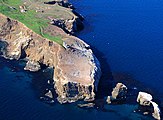
West-anacapa.jpg
Autor: Constantine, Licencja: CC BY-SA 3.0
West Anacapa Island, taken from East Anacapa.
Autor: Constantine, Licencja: CC BY-SA 3.0
West Anacapa Island, taken from East Anacapa.

AnacapaIsland-EO.jpg
NASA ASTER image of Anacapa Island, Channel Islands, California
NASA ASTER image of Anacapa Island, Channel Islands, California