Anantapur (dystrykt)
| dystrykt | |
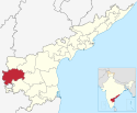
 Mapa stanu Andhra Pradesh, 2 – dystrykt Anantapur | |
| Państwo | |
|---|---|
| Stan | |
| Siedziba | Anantapur |
| Powierzchnia | 19 100 km² |
| Populacja (2011[1]) • liczba ludności |
|
| • gęstość | 214 os./km² |
Położenie na mapie Indii | |
| 14°40′48″N 77°36′00″E/14,680000 77,600000 | |
Anantapur – dystrykt w południowych Indiach, w stanie Andhra Pradesh. Stanowi jeden z trzynastu dystryktów stanu. Zajmuje powierzchnię 19 100 km². Siedzibą administracyjną jest miasto Anantapur.
Położenie
Dystrykt Anantapur położony jest na południu stanu. Graniczy:
- ze stanem Karnataka na zachodzie i południu graniczy,
- z dystryktem Karnulu od północy,
- z dystryktami: Kadapa i Chittoor od wschodu.
Demografia
W 2011 roku dystrykt zamieszkiwany był przez 4 081 148 osób, w tym 2 064 495 kobiet i 2 016 653 mężczyzn[1]. Mieszkańcy dystryktu stanowili 4,8% populacji stanu. W 2001 roku ludność jednostki wynosiła 3 640 478 osób, w tym 1 859 588 stanowili mężczyźni, a 1 780 890 kobiety[1].
Przypisy
- ↑ a b c Population Census 2011 (ang.). census2011.co.in. [dostęp 2015-01-28].
Bibliografia
- Andhra Pradesh Road Atlas & State Distance Guide. R.P.Arya (red.). Dźodhpur: Indian Map Service, 2005. ISBN 81-87460-07-5. (ang.)
Media użyte na tej stronie
Autor: Milenioscuro, Licencja: CC BY-SA 4.0
Location map of Andhra Pradesh. Coordinates:
- top=19.387
- bottom=12.522
- left=76.628
- right=84.935
(c) Uwe Dedering z niemieckiej Wikipedii, CC BY-SA 3.0
Location map of India.
Equirectangular projection. Strechted by 106.0%. Geographic limits of the map:
- N: 37.5° N
- S: 5.0° N
- W: 67.0° E
- E: 99.0° E
The Flag of India. The colours are saffron, white and green. The navy blue wheel in the center of the flag has a diameter approximately the width of the white band and is called Ashoka's Dharma Chakra, with 24 spokes (after Ashoka, the Great). Each spoke depicts one hour of the day, portraying the prevalence of righteousness all 24 hours of it.
Autor:
This Image was created by User:PlaneMad.
|
Autor: Milenioscuro, Licencja: CC BY-SA 4.0
Locator Map of District of Andhra Pradesh


