Andaman Północny
| ||
 | ||
| Kontynent | Azja | |
| Państwo | ||
| Akwen | Ocean Indyjski | |
| Archipelag | Wielki Andaman | |
| Powierzchnia | 1375,,99 km² | |
 | ||
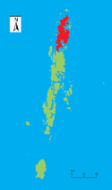
Andaman Północny – wyspa archipelagu Andamany leżącego we wschodniej części Oceanu Indyjskiego. Położona jest w północnej części grupy Wielki Andaman, który tworzy wraz z wyspami Andaman Środkowy, Andaman Południowy oraz wieloma mniejszymi. Wchodzi w skład indyjskiego terytorium związkowego Andamany i Nikobary.
Wyspa zajmuje powierzchnię 1376 km², a jej najwyższy szczyt Saddle Peak osiąga wysokość 738 m. Jest to zarazem najwyższy szczyt całego archipelagu. Główna miejscowość na wyspie to Diglipur.
Media użyte na tej stronie
Autor: Uwe Dedering, Licencja: CC BY-SA 3.0
Location map of India.
Equirectangular projection. Stretched by 106.0%. Geographic limits of the map:
- N: 37.5° N
- S: 5.0° N
- W: 67.0° E
- E: 99.0° E
The Flag of India. The colours are saffron, white and green. The navy blue wheel in the center of the flag has a diameter approximately the width of the white band and is called Ashoka's Dharma Chakra, with 24 spokes (after Ashoka, the Great). Each spoke depicts one hour of the day, portraying the prevalence of righteousness all 24 hours of it.
Autor: NordNordWest, Licencja: CC BY-SA 3.0 de
Location map of teh Andaman and Nicobar Islands, India


