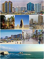
Antofagasta
| |||
 | |||
| |||
| Państwo | |||
|---|---|---|---|
| Region | Antofagasta | ||
| Burmistrz | Gonzalo Dantagnan | ||
| Powierzchnia | 30718,1 km² | ||
| Wysokość | 40 m n.p.m. | ||
| Populacja (2013) • liczba ludności • gęstość | 378 960[1] 12 os./km² | ||
| Nr kierunkowy | 5655943657654 | ||
| Kod pocztowy | 1240000 | ||
| Strona internetowa | |||
Antofagasta – miasto portowe w północnym Chile, nad Oceanem Spokojnym, ośrodek administracyjny regionu Antofagasta. W 2002 roku miejscowość miało 318,8 tys. mieszkańców.
W mieście rozwinął się przemysł chemiczny, spożywczy, włókienniczy oraz stoczniowy[2].
Miasta partnerskie
Przypisy
- ↑ Antofagasta - liczba ludności
- ↑ Antofagasta, [w:] Encyklopedia PWN [online] [dostęp 2021-05-29].
Media użyte na tej stronie
Łatwo można dodać ramkę naokoło tej grafiki
Made by author of Xramp, first uploaded by Denelson83 as Flag of Ecuador.svg, modifications by Husunqu.
The flag of Navassa Island is simply the United States flag. It does not have a "local" flag or "unofficial" flag; it is an uninhabited island. The version with a profile view was based on Flags of the World and as a fictional design has no status warranting a place on any Wiki. It was made up by a random person with no connection to the island, it has never flown on the island, and it has never received any sort of recognition or validation by any authority. The person quoted on that page has no authority to bestow a flag, "unofficial" or otherwise, on the island.
Łatwo można dodać ramkę naokoło tej grafiki
Autor: Autor nie został podany w rozpoznawalny automatycznie sposób. Założono, że to Marcos~commonswiki (w oparciu o szablon praw autorskich)., Licencja: CC BY 2.5
Costanera y puerto de Antofagasta (Antofagasta Terminal Internacional).
Autor: Victorddt, Licencja: CC BY-SA 3.0
Montage of Antofagasta city images.


