Antoing
 | |||||
| Państwo | |||||
|---|---|---|---|---|---|
| Region | |||||
| Prowincja | Hainaut | ||||
| Dystrykt | |||||
| Burmistrz | Bernard Bauwens | ||||
| Powierzchnia | 31,13 km² | ||||
| Populacja (2017 [1]) • liczba ludności • gęstość |
| ||||
| Nr kierunkowy | 069 | ||||
| Kod pocztowy | 7640-7643 | ||||
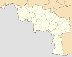
Położenie na mapie Belgii (c) Karte: NordNordWest, Lizenz: Creative Commons by-sa-3.0 de | |||||
| Strona internetowa | |||||
Antoing – gmina o statusie miasta (stad) w Belgii, w prowincji Hainaut. 7 684 tys. mieszkańców (2012). Łączna powierzchnia wynosi 31,13 km², co daje 250 osoby/km².
Składa się z miejscowości: Antoing, Maubray, Péronnes-lez-Antoing, Bruyelle, Calonne and Fontenoy.
W Antoing znajduje się Zamek Antoing[2]. 11 maja 1745 roku na terenie aktualnej gminy Antoing odbyła się Bitwa pod Fontenoy.
Przypisy
- ↑ Stan na 1 stycznia 2017 roku, Direction générale Institutions et Population: Chiffres de la population par province et par commune, à la date du premier janvier 2017 (fr.). [dostęp 2017-01-01].
- ↑ Informacje o zamku
Media użyte na tej stronie
(c) Karte: NordNordWest, Lizenz: Creative Commons by-sa-3.0 de
Location map of Belgium
Autor: Milenioscuro, Licencja: CC BY-SA 3.0
Location map of Hainaut province, Belgium
Autor: Jean-Pol GRANDMONT, Licencja: CC BY 2.5
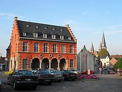
Antoing (Belgium), the town hall (1565).
Blazon of the town of Antoing, Belgium: Gules, a lion rampant argent. Also arms of Mowbray family: Gules, a lion rampant argent
Municipal flag of Antoing, Belgium. The municipal flag of Antoing is made of six wavy diagonal stripes, alternatively red and white.


