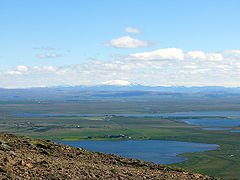
Apavatn
 | |
| Położenie | |
| Państwo | |
|---|---|
| Morfometria | |
| Powierzchnia | 13 km² |
Apavatn – jezioro na południowym zachodzie Islandii, o powierzchni około 13 km².
Media użyte na tej stronie
Legenda jezioro.gif
Autor: Tzugaj, Licencja: CC0
znak graficzny do map, ukazujący przykładowe jezioro
Autor: Tzugaj, Licencja: CC0
znak graficzny do map, ukazujący przykładowe jezioro
Laugarvatn01.jpg
Autor: Christian Bickel, Licencja: CC BY-SA 2.0 de
The lakes Laugarvaten and Apavatn from mount Laugarvatnsfjall. In the background Mount Hekla.
Autor: Christian Bickel, Licencja: CC BY-SA 2.0 de
The lakes Laugarvaten and Apavatn from mount Laugarvatnsfjall. In the background Mount Hekla.
Iceland relief map.jpg
Autor:
Location map of Iceland
Autor:
- Iceland_location_map.svg: NordNordWest
- derivative work: Виктор В (talk)
Location map of Iceland


