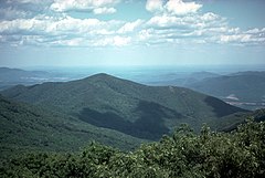
Appalachy
 Appalachy w Karolinie Północnej | |
| Kontynent | |
|---|---|
| Państwo | |
| Najwyższy szczyt | Mount Mitchell |
| Długość | 2600 km |
 Lokalizacja Appalachów na mapie Ameryki Północnej | |
| 38°00′00,0000″N 79°00′00,0000″W/38,000000 -79,000000 | |
Appalachy (ang. Appalachian Mountains, fr. Appalaches) – łańcuch górski we wschodniej części Ameryki Północnej, w USA i Kanadzie.

Rozciągają się od Niziny Zatokowej w kierunku północno-wschodnim do Nowej Fundlandii, na długości 2600 km (szerokość od 300 do 500 km). Najwyższym szczytem jest Mount Mitchell – 2037 m n.p.m.
Północno-wschodnia część Appalachów powstała w orogenezie kaledońskiej, a część południowo-zachodnia w hercyńskiej (appalachijskiej). Appalachy są zbudowane ze skał osadowych prekambru i paleozoiku. Zapadliska rzek Hudson i Mohawk dzielą Appalachy na Północne i Południowe.
W Appalachach występują głównie lasy mieszane. Są złoża węgla kamiennego, rud żelaza i cynku, ropy naftowej, gazu ziemnego, grafitu i marmuru.
Wzdłuż Appalachów wytyczono Szlak Appalachów (Appalachian Trail) o długości 3476 km.
Zobacz też
- Pasma górskie Appalachów: Pasmo Błękitne, Góry Białe i Zielone, Allegheny
- Adirondack – pobliskie, odrębne pasmo górskie
- Dolina Appalaska, Wyżyny Appalaskie
Media użyte na tej stronie
The flag of Navassa Island is simply the United States flag. It does not have a "local" flag or "unofficial" flag; it is an uninhabited island. The version with a profile view was based on Flags of the World and as a fictional design has no status warranting a place on any Wiki. It was made up by a random person with no connection to the island, it has never flown on the island, and it has never received any sort of recognition or validation by any authority. The person quoted on that page has no authority to bestow a flag, "unofficial" or otherwise, on the island.
Flag of Canada introduced in 1965, using Pantone colors. This design replaced the Canadian Red Ensign design.
Black up-pointing triangle ▲, U+25B2 from Unicode-Block Geometric Shapes (25A0–25FF)
Autor: Uwe Dedering, Licencja: CC BY-SA 3.0
Relief location map of North America.
- Projection: Lambert azimuthal equal-area projection.
- Area of interest:
- N: 90.0° N
- S: 5.0° N
- W: -140.0° E
- E: -60.0° E
- Projection center:
- NS: 47.5° N
- WE: -100.0° E
- GMT projection: -JA-100/47.5/20.0c
- GMT region: -R-138.3726888474925/-3.941007863604182/2.441656573833029/50.63933645705661r
- GMT region for grdcut: -R-220.0/-4.0/20.0/90.0r
- Relief: SRTM30plus.
- Made with Natural Earth. Free vector and raster map data @ naturalearthdata.com.
Zdjęcie satelitarne Appalachów w stanie Wirginia
Inaccurate map of the Appalachian Mountains shown in the Eastern United States and Eastern Canada.


