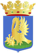
Appingedam
(c) Thijs nl, CC-BY-SA-3.0 | |||||
| |||||
| Państwo | |||||
|---|---|---|---|---|---|
| Prowincja | |||||
| Burmistrz | Rika Pot (2014)[1] | ||||
| Powierzchnia | 24,62 km² | ||||
| Populacja (2008) • liczba ludności • gęstość | 12 144 509 os./km² | ||||
| Nr kierunkowy | 0596 | ||||
| Kod pocztowy | 9900-9903 | ||||
| Strona internetowa | |||||
Appingedam – miasto i gmina w północnej Holandii (prowincja Groningen). Liczy ok. 12 tys. mieszkańców (2008).
Gmina składa się z dziewięciu miejscowości: Appingedam, Garreweer, Jukwerd, Laskwerd, Marsum, Oling, Opwierde, Solwerd oraz Tjamsweer.
Przypisy
- ↑ appingedam.nl: Burgemeester H.K. Pot (niderl.). [dostęp 2014-07-09]. [zarchiwizowane z tego adresu (2013-12-31)].
Media użyte na tej stronie
Flag of the Province of Groningen, Netherlands. See for a photo of the flag. For colour conversions for Pantone were used coated instead of uncoated colours. The chart used was Commons:Pantone color chart.
Flag of the Dutch municipality of Appingedam.
Autor: Erik Frohne, Licencja: CC BY-SA 3.0
Location map of province Groningen in the Netherlands
Equirectangular projection, N/S stretching 167 %. Geographic limits of the map:
- N: 53.60° N
- S: 52.80° N
- W: 6.10° E
- E: 7.30° E
Coat of arms of the Dutch municipality of Appingedam.


