Arc du Carrousel
 | |
| Państwo | |
|---|---|
| Region | |
| Miejscowość | |
| Typ budynku | |
| Rozpoczęcie budowy | |
| Ukończenie budowy | |
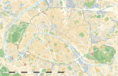
Położenie na mapie Paryża (c) Eric Gaba, Wikimedia Commons user Sting, CC BY-SA 3.0 | |
Położenie na mapie Île-de-France (c) Eric Gaba, Wikimedia Commons user Sting, CC BY-SA 3.0 | |
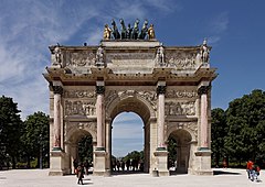
Arc de Triomphe du Carrousel – łuk triumfalny w Paryżu. Znajduje się na Place du Carrousel, niedaleko Luwru.
Historia
Łuk został zaprojektowany na zlecenie cesarza Napoleona przez Charlesa Perciera i Pierre'a Fontaine'a i był wzorowany na łuku Konstantyna w Rzymie. Upamiętnia on wojskowe i dyplomatyczne zwycięstwa Napoleona, m.in. bitwę pod Austerlitz, poddanie Ulm, pokój w Preszburgu i traktaty tylżyckie[1].
Budowę przeprowadzono w latach 1806-1808. Początkowo na szczycie łuku były ustawione cztery konie z fasady weneckiej bazyliki świętego Marka, ale zostały zwrócone Wenecji w 1815 roku i zastąpione przez kwadrygę zaprojektowaną przez François Bosio. Po obu stronach kwadrygi stoją rzeźby zwycięstwa.
Zobacz też
Przypisy
- ↑ Arc du Carrousel w Paryżu (pol.). Paryż.pl. [dostęp 2019-11-26].
Media użyte na tej stronie
(c) Eric Gaba, Wikimedia Commons user Sting, CC BY-SA 3.0
Blank land cover map of the city and department of Paris, France, as in January 2012, for geo-location purpose, with distinct boundaries for departments and arrondissements.
Autor: Superbenjamin, Licencja: CC BY-SA 4.0
Blank administrative map of France for geo-location purpose, with regions and departements distinguished. Approximate scale : 1:3,000,000
(c) Eric Gaba, Wikimedia Commons user Sting, CC BY-SA 3.0
Blank administrative map of the region of Île-de-France, France, as in January 2015, for geo-location purpose, with distinct boundaries for regions, departments and arrondissements.
Blue Shield - the Distinctive emblem for the Protection of Cultural Property. The distinctive emblem is a protective symbol used during armed conflicts. Its use is restricted under international law.
Autor: Patricia.fidi, Licencja: CC0
Unofficial (de facto) flag of the region Île-de-France in France. It was also the flag of the kingdom of France (s.XIV-XV)
Autor: Thesupermat, Licencja: CC BY-SA 3.0
L'arc de triomphe du Carrousel dans le jardin des Tuileries.


