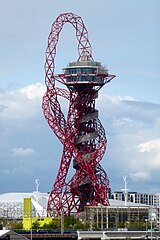
ArcelorMittal Orbit
 | |
| Państwo | |
|---|---|
| Miejscowość | Londyn |
| Typ budynku | wieża widokowa |
| Architekt | Anish Kapoor i Cecil Balmond |
| Wysokość całkowita | 115 m |
| Rozpoczęcie budowy | 2010 |
| Ukończenie budowy | maj 2012 |
Położenie na mapie gminy Newham Contains Ordnance Survey data © Crown copyright and database right, CC BY-SA 3.0 | |
Położenie na mapie Wielkiej Brytanii (c) Karte: NordNordWest, Lizenz: Creative Commons by-sa-3.0 de | |
Położenie na mapie Wielkiego Londynu Contains Ordnance Survey data © Crown copyright and database right, CC BY-SA 3.0 | |
| Strona internetowa | |
ArcelorMittal Orbit – 115-metrowa wieża widokowa zbudowana w pobliżu Stadionu Olimpijskiego z okazji Letnich Igrzysk Olimpijskich w Londynie. Głównym sponsorem budowy wieży był koncern stalowy ArcelorMittal.
Bibliografia
- Londyn u stóp ArcelorMittal Orbit. gazeta.pl, 2010-04-06. [dostęp 2012-05-07].
Media użyte na tej stronie
(c) Karte: NordNordWest, Lizenz: Creative Commons by-sa-3.0 de
Location map of the United Kingdom
Contains Ordnance Survey data © Crown copyright and database right, CC BY-SA 3.0
Blank map of the London Borough of Newham, showing electoral wards.
Equirectangular map projection on WGS 84 datum, with N/S stretched 160%
Geographic limits:
- West: 0.03W
- East: 0.1E
- North: 51.57N
- South: 51.49N
Autor: Cmglee, Licencja: CC BY-SA 3.0
ArcelorMittal Orbit viewed from Stratford High Street (A118).
Contains Ordnance Survey data © Crown copyright and database right, CC BY-SA 3.0
Map of Greater London, UK with the following information shown:
- Administrative borders
- Coastline, lakes and rivers
- Roads and railways
- Urban areas
The data includes both primary routes and railway lines.
Equirectangular map projection on WGS 84 datum, with N/S stretched 160%
Geographic limits:
- West: 0.57W
- East: 0.37E
- North: 51.72N
- South: 51.25N


