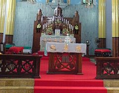
Archieparchia Kottayam
 | |
| Państwo | |
|---|---|
| Siedziba | Kottayam |
| Data powołania | |
| Wyznanie | |
| Kościół | |
| Metropolia | Kottayam |
| Katedra | Chrystusa Króla |
| Biskup diecezjalny | |
| Biskup pomocniczy | |
| Dane statystyczne (2016) | |
| Liczba wiernych • odsetek wiernych | 185 721 |
| Liczba kapłanów • w tym diecezjalnych • w tym zakonnych | 465 |
| Liczba osób zakonnych | 1 206 |
| Liczba parafii | 147 |
| Powierzchnia | 560665 km² |
Położenie na mapie Indii | |
| 9,589225°N 76,527425°E/9,589225 76,527425 | |
| Strona internetowa | |
Archieparchia Kottayam (łac. Archieparchia Kottayamensis; ang. Archeparchy of Kottayam (Syro-Malabarese)) – syromalabarska archieparchia ze stolicą w Kottayam w stanie Kerala, w Indiach. Powstała 20 maja 1887 jako wikariat apostolski (do 28 lipca 1896; i ponownie od 29 sierpnia 1911). Ustanowiona diecezją 21 grudnia 1923 bullą papieża Piusa XI, a podniesiona do rangi archidiecezji przez Benedykta XVI bullą z dnia 9 maja 2005. Arcybiskupi Kottayam są również metropolitami metropolii o tej samej nazwie, jednak metropolia Kottayam nie posiada żadnej sufraganii.
Bibliografia
- Archieparchia Kottayam w bazie catholic-hierarchy.org (ang.)
- Archieparchia Kottayam w bazie gcatholic.org (ang.) [dostęp 15.08.2020]
Media użyte na tej stronie
(c) Uwe Dedering z niemieckiej Wikipedii, CC BY-SA 3.0
Location map of India.
Equirectangular projection. Strechted by 106.0%. Geographic limits of the map:
- N: 37.5° N
- S: 5.0° N
- W: 67.0° E
- E: 99.0° E
The Flag of India. The colours are saffron, white and green. The navy blue wheel in the center of the flag has a diameter approximately the width of the white band and is called Ashoka's Dharma Chakra, with 24 spokes (after Ashoka, the Great). Each spoke depicts one hour of the day, portraying the prevalence of righteousness all 24 hours of it.
Japanese map symbol "Church". U+26EA
Autor: Autor nie został podany w rozpoznawalny automatycznie sposób. Założono, że to Robin klein (w oparciu o szablon praw autorskich)., Licencja: CC-BY-SA-3.0
This Picture shows the interior of a "Palli" or Church. It shows the unveiled tabernacle of a Knanaya temple, with the Nasrani Menorah in Silver in the foreground on the table and 12 candlestands in the background representing the 12 tribes of Israel.
This picture was photographed by me in November 2006 in Kottayam in Kerala in South India. Robin klein 21:22, 5 November 2006 (UTC)


