Archikatedra Chrystusa Króla w Liverpoolu
| katedra | |||||||||||
 Katedra Metropolitalna w Liverpoolu | |||||||||||
| Państwo | |||||||||||
|---|---|---|---|---|---|---|---|---|---|---|---|
| Kraj | |||||||||||
| Miejscowość | |||||||||||
| Wyznanie | |||||||||||
| Kościół | |||||||||||
| Archidiecezja | |||||||||||
| Wezwanie | |||||||||||
| |||||||||||
| |||||||||||
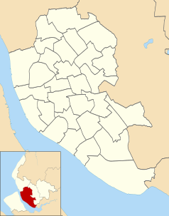
Położenie na mapie Liverpoolu Contains Ordnance Survey data © Crown copyright and database right, CC BY-SA 3.0 | |||||||||||
Położenie na mapie Wielkiej Brytanii (c) Karte: NordNordWest, Lizenz: Creative Commons by-sa-3.0 de | |||||||||||
Położenie na mapie Merseyside Contains Ordnance Survey data © Crown copyright and database right, CC BY-SA 3.0 | |||||||||||
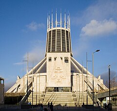
Archikatedra Chrystusa Króla w Liverpoolu (ang. Liverpool Metropolitan Cathedral of Christ the King, Liverpool) – główna świątynia archidiecezji Liverpoolu kościoła rzymskokatolickiego pod wezwaniem Chrystusa Króla. Jest to postmodernistyczna budowla wybudowana w latach 1962–1967, zaprojektowana przez architektów Fredericka Gibberda i Edwina Luytensa (wcześniejsza krypta wzniesiona w latach 1933–1940). Godność katedry posiada od 1967. Świątynia została konsekrowana 14 maja 1967 roku, w dzień Zesłania Ducha Świętego.
Bibliografia
Media użyte na tej stronie
(c) Karte: NordNordWest, Lizenz: Creative Commons by-sa-3.0 de
Location map of the United Kingdom
Contains Ordnance Survey data © Crown copyright and database right, CC BY-SA 3.0
Map of Merseyside, UK with the following information shown:
- Administrative borders
- Coastline, lakes and rivers
- Roads and railways
- Urban areas
Equirectangular map projection on WGS 84 datum, with N/S stretched 165%
Geographic limits:
- West: 3.24W
- East: 2.54W
- North: 53.72N
- South: 53.27N
Blue Shield - the Distinctive emblem for the Protection of Cultural Property. The distinctive emblem is a protective symbol used during armed conflicts. Its use is restricted under international law.
Flag of England. Saint George's cross (a red cross on a white background), used as the Flag of England, the Italian city of Genoa and various other places.
Contains Ordnance Survey data © Crown copyright and database right, CC BY-SA 3.0
Map of Liverpool, Merseyside, UK with electoral wards shown.
Equirectangular map projection on WGS 84 datum, with N/S stretched 165%
Geographic limits:
- West: 3.02W
- East: 2.80W
- North: 53.48N
- South: 53.31N


