Archipelag Aleksandra
 Zdjęcie satelitarne Archipelagu Aleksandra zimą | |
| Kontynent | Ameryka Północna |
|---|---|
| Państwo | |
| Stan | |
| Akwen | |
| Wyspy | |
| Liczba wysp | 1100 |
| Powierzchnia | 35 000 km² |
| Populacja • liczba ludności |
|
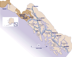
Mapa | |
Archipelag Aleksandra (ang. Alexander Archipelago) − archipelag u południowo-wschodnich wybrzeży stanu Alaska. W jego skład wchodzi około 1100 wysp, które powstały w wyniku zalania nadbrzeżnych pasm górskich z powodu podniesienia się poziomu wody Oceanu Spokojnego. Wyspy oddzielone są od siebie i stałego lądu głębokimi cieśninami o charakterze fiordów. Wyspy mają łączną powierzchnię ok. 35 tys. km², są górzyste i gęsto zalesione.
Największe wyspy archipelagu to: Wyspa Księcia Walii, Wyspa Cziczagowa, Wyspa Baranowa, Wyspa Admiralicji, Wyspa Kupriejanowa i Revillagigedo. Jedna z mniejszych wyspy archipelagu nosi imię Kościuszki. W archipelagu tym znajduje się również Woewodski Island, która wzięła swoją nazwę od dyrektora Kompanii Rosyjsko-Amerykańskiej, Stefana Wojewódzkiego. Najważniejsze miasta w Archipelagu Aleksandra to Ketchikan na wyspie Revillagigedo i Sitka na wyspie Baranowa. Podstawą gospodarki wysp jest turystyka, rybołówstwo i leśnictwo.
Wyspy pierwotnie zamieszkane były przez ludy Tlingit i Kaigani Haida. Pierwszymi Europejczykami na wyspach byli w 1741 Rosjanie z wyprawy Vitusa Beringa i Aleksieja Czirikowa. W 1867 wraz z Alaską zostały sprzedane Stanom Zjednoczonym.
Nazwa wysp pochodzi od imienia cara Aleksandra II, została nadana przez U.S. Coast and Geodetic Survey w 1867 roku[1].
Przypisy
- ↑ Donald J. Orth: Dictionary of Alaska Place Names. Waszyngton: U.S. Government Printing Office, 1967, s. 64.
Media użyte na tej stronie
The flag of Navassa Island is simply the United States flag. It does not have a "local" flag or "unofficial" flag; it is an uninhabited island. The version with a profile view was based on Flags of the World and as a fictional design has no status warranting a place on any Wiki. It was made up by a random person with no connection to the island, it has never flown on the island, and it has never received any sort of recognition or validation by any authority. The person quoted on that page has no authority to bestow a flag, "unofficial" or otherwise, on the island.
Autor: Uwe Dedering, Licencja: CC BY-SA 3.0
Relief location map of North America.
- Projection: Lambert azimuthal equal-area projection.
- Area of interest:
- N: 90.0° N
- S: 5.0° N
- W: -140.0° E
- E: -60.0° E
- Projection center:
- NS: 47.5° N
- WE: -100.0° E
- GMT projection: -JA-100/47.5/20.0c
- GMT region: -R-138.3726888474925/-3.941007863604182/2.441656573833029/50.63933645705661r
- GMT region for grdcut: -R-220.0/-4.0/20.0/90.0r
- Relief: SRTM30plus.
- Made with Natural Earth. Free vector and raster map data @ naturalearthdata.com.
West of British Columbia, Canada, and south of the Yukon Territory, the southeastern coastline of Alaska trails off into the islands of the Alexander Archipelago. The area is rugged and contains many long, U-shaped, glaciated valleys, many of which terminate at tidewater. The Alexander Archipelago is home to Glacier Bay National Park. The large bay that has two forks on its northern end is Glacier Bay itself. The eastern fork is Muir inlet, into which runs the Muir glacier, named for the famous Scottish-born naturalist John Muir. Glacier Bay opens up into the Icy Strait. The large, solid white area to the west is Brady Icefield, which terminates at the southern end in Brady's Glacier.
Shiny LightSteelBlue button/marker widget. Used to mark the location of something such as a tourist attraction.
Autor: Wikisoft* @@@-fr 07:08, 27 April 2011 (UTC), Licencja: GFDL
Carte Alaska Relief R3 jpg (Changement des couleurs)


