Arcipelago della Maddalena
 Od lewej wyspy Maddalena, Santo Stefano, Caprera | |
| Kontynent | |
|---|---|
| Państwo | |
| Region autonomiczny | |
| Akwen | |
| Liczba wysp | 7 (większe wyspy) |
| Powierzchnia | 51,34 km² |
Położenie na mapie Sardynii  © Sémhur / Wikimedia Commons, CC BY-SA 4.0 | |
Położenie na mapie Włoch  | |
Arcipelago della Maddalena – włoski archipelag położony u północno-wschodnich wybrzeży Sardynii. Wyspy leżą na Szmaragdowym Wybrzeżu (wł. Costa Smeralda). Cieśnina Świętego Bonifacego oddziela archipelag od francuskich wysp Korsyki i Cavallo.
W 1994 powstał tu Park Narodowy Arcipelago della Maddalena obejmujący wszystkie wyspy archipelagu[1].
Największe Wyspy
| Wyspa | Powierzchnia (km²) | Najwyższe wzniesienie (m n.p.m.) |
|---|---|---|
| Maddalena | 19,60 | 156 |
| Caprera | 15,75 | 212 |
| Santo Stefano | 2,97 | 101 |
| Spargi | 4,20 | 155 |
| Budelli | 1,64 | 87 |
| Razzoli | 1,54 | 65 |
| Santa Maria | 2,05 | 49 |
Galeria

Wybrzeże wyspy Maddalena
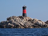
Latarnia morska na wyspie Barrettinelli di Fuori

Port w La Maddalena

Latarnia morska na Santo Stefano

Wyspa Spargi

Wyspa Budelli

Wyspa Santa Maria

Wyspa Razzoli
Przypisy
- ↑ Cronistoria del Parco e del suo Ente gestore. lamaddalenapark.it. [dostęp 2015-07-12]. [zarchiwizowane z tego adresu (2015-07-12)]. (wł.).
Linki zewnętrzne
- La Geografia di dell'arcipelago. lamaddalena.it. [dostęp 2015-07-12]. (wł.).
- Park Narodowy Archipelagu La Maddalena. podroze.onet.pl. [dostęp 2015-07-12]. (pol.).
Media użyte na tej stronie


San-Stefano-From-Palau.jpg
Autor: Autor nie został podany w rozpoznawalny automatycznie sposób. Założono, że to Nicklott~commonswiki (w oparciu o szablon praw autorskich)., Licencja: CC BY 2.5
Looking across at I. San Stefano from Palau on an October evening.
Autor: Autor nie został podany w rozpoznawalny automatycznie sposób. Założono, że to Nicklott~commonswiki (w oparciu o szablon praw autorskich)., Licencja: CC BY 2.5
Looking across at I. San Stefano from Palau on an October evening.
.JPG)
Isola di Santa Maria - Faro di Punta Filetto (01).JPG
Autor: Gianni Careddu, Licencja: CC BY-SA 3.0
Isola di Santa Maria - Faro di Punta Filetto
Autor: Gianni Careddu, Licencja: CC BY-SA 3.0
Isola di Santa Maria - Faro di Punta Filetto
.JPG)

La Maddalena 2.JPG
Autor: Paolo De Carolis, Licencja: CC BY-SA 3.0
This is a photo of a monument which is part of cultural heritage of Italy. This monument participates in the contest Wiki Loves Monuments Italia 2012. See authorisations.
Autor: Paolo De Carolis, Licencja: CC BY-SA 3.0
This is a photo of a monument which is part of cultural heritage of Italy. This monument participates in the contest Wiki Loves Monuments Italia 2012. See authorisations.
Italy Sardinia relief location map.svg
© Sémhur / Wikimedia Commons, CC BY-SA 4.0
Blank physical map of Sardinia, Italy, for geo-location purpose, with province boundaries. Altitude levels : 25m, 50, 100, 200, 400, 600, etc. (same for bathymetry).
© Sémhur / Wikimedia Commons, CC BY-SA 4.0
Blank physical map of Sardinia, Italy, for geo-location purpose, with province boundaries. Altitude levels : 25m, 50, 100, 200, 400, 600, etc. (same for bathymetry).

Flag of Sardinia.svg
Autor:
Flag of the Italian autonomous region Sardinia.
Autor:
- Bandiera ufficiale RAS.jpg: icnussa / praca pochodna: Xander89
Flag of the Italian autonomous region Sardinia.

Lighthouse Faro di Razzoli.jpg
Autor: Arnoldius, Licencja: CC BY-SA 3.0
Leuchtturm auf der Insel Razzoli, aus südlicher Sicht, Nord-Sardinien (41.307181N; 9.34001E)
Autor: Arnoldius, Licencja: CC BY-SA 3.0
Leuchtturm auf der Insel Razzoli, aus südlicher Sicht, Nord-Sardinien (41.307181N; 9.34001E)

Isola di Budelli. Arcipelago della Maddalena.JPG
Autor: Mattia.dipaolo, Licencja: CC BY-SA 3.0
This is a photo of a monument which is part of cultural heritage of Italy. This monument participates in the contest Wiki Loves Monuments Italia 2012. See authorisations.
Autor: Mattia.dipaolo, Licencja: CC BY-SA 3.0
This is a photo of a monument which is part of cultural heritage of Italy. This monument participates in the contest Wiki Loves Monuments Italia 2012. See authorisations.

Steel pog.svg
Shiny LightSteelBlue button/marker widget. Used to mark the location of something such as a tourist attraction.
Shiny LightSteelBlue button/marker widget. Used to mark the location of something such as a tourist attraction.
Italy relief location map.jpg
Autor: Eric Gaba (Sting - fr:Sting) and NordNordWest, Licencja: CC BY-SA 3.0
Blank physical map of Italy including the 08-2009 modification of the boundary between Emilia-Romagna and Marche regions, for geo-location purpose.
Autor: Eric Gaba (Sting - fr:Sting) and NordNordWest, Licencja: CC BY-SA 3.0
Blank physical map of Italy including the 08-2009 modification of the boundary between Emilia-Romagna and Marche regions, for geo-location purpose.


Lighthouse Faro Barrettinelli di Fuori 03.jpg
Autor: Arnoldius, Licencja: CC BY-SA 3.0
Leuchtturm auf der Insel Barrettinelli, nördlich der Insel Corcelli, Maddalena Archipel, Nord-Sardinien (41.301612N; 9.400877E)
Autor: Arnoldius, Licencja: CC BY-SA 3.0
Leuchtturm auf der Insel Barrettinelli, nördlich der Insel Corcelli, Maddalena Archipel, Nord-Sardinien (41.301612N; 9.400877E)