Ardabil (ostan)
| Ostan | |
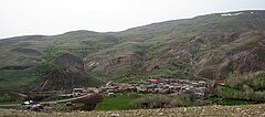
 Wioska Pirbidaq w ostanie Ardabil | |
| Państwo | |
|---|---|
| Siedziba | |
| Powierzchnia | 17 800 km² |
| Populacja • liczba ludności |
|
Położenie na mapie | |
Ardabil (farsi اردبیل; azerski Ərdəbil ostanı) – ostan w zachodnim Iranie. Stolicą jest Ardabil.
Ardabil powstał w 1993 z części Azerbejdżanu Wschodniego i północnej części Gilanu[1]. Ostan liczy 17 800 km² powierzchni[2]. Według spisu z 2011 ludność wynosi 1 248 488 mieszkańców; dla porównania, w 2006 było ich 1 228 155, natomiast w 1996 – 1 168 011. Do największych miast stanu, według spisu ludności z 2011, należy Ardabil, Parsabad, Meszginszahr, Chalchal.
Ostan dzieli się na 10 podprowincji (shahrestan)[2].
Przypisy
- ↑ Provinces. en.iran.ir. [dostęp 2014-11-01]. [zarchiwizowane z tego adresu (1 listopada 2014)].
- ↑ a b Iran. Administrative units. GeoHive. [dostęp 2014-11-01].
Media użyte na tej stronie
Pirbidaq is a village in Kowsar County, Ardabil province, Iran.
State emblem of the Islamic Republic of Iran. U+262B, stylized version of Arabic script of Allah (الله, with the central lam shaped to look like a sword.) The emblem is also an overlaid rendering of La Ilaha Illa Allah (There is only one God and that is 'Allah'). The exact shape of the emblem and an algorithmic ruler-and-compass construction is described in the national Iranian standard at IRANIAN ISLAMIC REPUBLIC FLAG, ISIRI 1, 1371, 3rd edition, March 1993 in Persian. The emblem was designed by Hamid Nadimi, and was officially approved by Ayatollah Khomeini on May 9, 1980.
Autor: Original work by Uwe Dering. Highlighted by Dr. Blofeld, Licencja: CC BY-SA 3.0
Locator map of Iran


