Arendonk
 | |||||
| Państwo | |||||
|---|---|---|---|---|---|
| Region | |||||
| Prowincja | |||||
| Zarządzający | Kristof Hendrickx↗ | ||||
| Populacja • liczba ludności |
| ||||
| Nr kierunkowy | 014 | ||||
| Kod pocztowy | 2370 | ||||
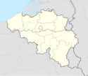
Położenie na mapie Belgii (c) Karte: NordNordWest, Lizenz: Creative Commons by-sa-3.0 de | |||||
| 51°19′13″N 5°05′11″E/51,320278 5,086389 | |||||
| Strona internetowa | |||||
Arendonk – miejscowość i gmina w Belgii, w prowincji Antwerpia. W 2018 roku liczyła 13 281 mieszkańców.
Media użyte na tej stronie
Flag of Arendonk.svg
Flag of Arendonk; the blue represents water (brooks, fens and ponds) and the yellow the sandy heights (kruisberg, hoge heide)
Flag of Arendonk; the blue represents water (brooks, fens and ponds) and the yellow the sandy heights (kruisberg, hoge heide)
Arendonk - Onze-Lieve-Vrouw ten Hemel Opgenomenkerk.jpg
Autor: Sonuwe, Licencja: CC BY-SA 3.0
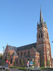
Church of the Assumption of the Virgin Mary in Arendonk, Antwerp, Belgium
Autor: Sonuwe, Licencja: CC BY-SA 3.0
Church of the Assumption of the Virgin Mary in Arendonk, Antwerp, Belgium
Belgium adm location map.svg
(c) Karte: NordNordWest, Lizenz: Creative Commons by-sa-3.0 de
Location map of Belgium
(c) Karte: NordNordWest, Lizenz: Creative Commons by-sa-3.0 de
Location map of Belgium


