Arrou
| miejscowość i gmina | |||
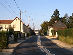
 Ulica w miejscowości Arrou | |||
| |||
| Państwo | |||
|---|---|---|---|
| Region | |||
| Departament | |||
| Okręg | |||
| Kod INSEE | 28012 | ||
| Powierzchnia | 65,81 km² | ||
| Populacja (2013) • liczba ludności |
| ||
| Kod pocztowy | 28290 | ||
| Portal | |||
Arrou – miejscowość i gmina we Francji, w Regionie Centralnym, w departamencie Eure-et-Loir. W 2013 roku populacja gminy wynosiła 1658 mieszkańców[1].
1 stycznia 2017 roku połączono sześć wcześniejszych gmin: Arrou, Boisgasson, Châtillon-en-Dunois, Courtalain, Langey oraz Saint-Pellerin. Siedzibą gminy została miejscowość Arrou, a nowa gmina przyjęła jej nazwę[2].
Przypisy
- ↑ Populations légales 2013. INSEE. [dostęp 2017-01-31]. (fr.).
- ↑ AP création commune nouvelle d'Arrou. eure-et-loir.gouv.fr. [dostęp 2017-01-31]. (fr.).
Media użyte na tej stronie
Autor: Superbenjamin, Licencja: CC BY-SA 4.0
Blank administrative map of France for geo-location purpose, with regions and departements distinguished. Approximate scale : 1:3,000,000
Autor: Flappiefh, Licencja: CC BY-SA 4.0
Carte administrative vierge de la région Centre-Val de Loire, France, destinée à la géolocalisation.
Autor: Benjism89, Licencja: CC-BY-SA-3.0
One of the main streets in Arrou, Eure-et-Loir, France
Autor: Flappiefh, Licencja: CC BY-SA 4.0
Blank administrative map of the department of Eure-et-Loir, France, for geo-location purpose.


