Artas (Betlejem)
 | |
| Państwo | / |
|---|---|
| Muhafaza | Betlejem |
| Populacja (2016) • liczba ludności | 4610 |
| 31°41′21″N 35°11′10″E/31,689167 35,186111 | |
Artas – wieś w Palestynie, w muhafazie Betlejem. Według danych Palestyńskiego Centralnego Biura Statystycznego w 2016 roku miejscowość liczyła 4610 mieszkańców[1].
Przypisy
- ↑ Localities in Bethlehem Governorate by Type of Locality and Population Estimates, 2007–2016 (ang.). Palestinian Central Bureau of Statistics. [dostęp 2018-09-08].
Media użyte na tej stronie
Flag of Israel. Shows a Magen David (“Shield of David”) between two stripes. The Shield of David is a traditional Jewish symbol. The stripes symbolize a Jewish prayer shawl (tallit).
Autor: Artas Folklore Center, Licencja: CC-BY-SA-3.0
This lovely church, built at the turn of the twentieth century, is located across the Artas Valley from the village of the same name. In fact, "Artas" is thought to be derived from "Hortus Conclusus," alluding to a verse from the Song of Solomon. Ethnographers have found many parallels with that canticle in the traditions of the village. The association extends to the nearby Solomon Pools, traditionally guarded by the villagers of Artas during the Ottoman period, and equally present in their folklore. The existence of the convent in the midst of an entirely Muslim village attests to the centuries of peaceful coexistence between Christians and Moslems in the Holy Land. The Soler Park adjoining the Convent often served as the site of the Annual Artas Lettuce Festival before it outgrew the space. For more information see www.artasfolklorecenter.net
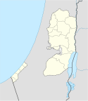
Map of the Palestinian Authorities showing the Governate of Bethlehem
Autor: NordNordWest, Licencja: CC BY-SA 3.0
Location map of the Palestinian territories (West Bank and Gaza Strip)


