Artemisa (prowincja)
| prowincja | |||
| |||
| Państwo | |||
|---|---|---|---|
| Siedziba | Artemisa | ||
| Powierzchnia | 4.004,27 km² | ||
| Populacja (2010) • liczba ludności |
| ||
| • gęstość | 125,5 os./km² | ||
| Numer kierunkowy | +53-47 | ||
| Plan | |||
 | |||
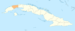
Położenie na mapie | |||
| 22°48′49″N 82°45′48″W/22,813611 -82,763333 | |||
Artemisa – jedna z prowincji Kuby. Jednostka została utworzona 1 stycznia 2011 roku na mocy decyzji Zgromadzenia Narodowego Władzy Ludowej z 1 sierpnia 2010 roku nt. podziału prowincji Hawana i zmiany granic prowincji Pinar del Río[1][2][3]. Prowincja składa się z 8 gmin z zachodniej części byłej prowincji Hawana i 3 gmin ze wschodniej części prowincji Pinar del Río. Stolicą i największym miastem prowincji jest Artemisa.
Ludność zajmuje się głównie uprawą owoców, ziemniaków, ryżu, warzyw, trzciny cukrowej oraz pracą w przemyśle budowlanym i spożywczym.
| Gmina | km² | Populacja |
|---|---|---|
| Mariel | 270,85 | 44.786 |
| Guanajay | 110,26 | 28.750 |
| Caimito | 239,4 | 39.304 |
| Bauta | 155,13 | 48.024 |
| San Antonio de los Baños | 126,37 | 49.942 |
| Güira de Melena | 199,22 | 39.821 |
| Alquízar | 194,36 | 32.501 |
| Artemisa | 688,7 | 82.917 |
| Bahía Honda | 784,14 | 45.124 |
| Candelaria | 301,42 | 20.283 |
| San Cristóbal | 934,4 | 70.940 |
| Razem | 4.004,27 | 502.392 |
Przypisy
- ↑ La racionalidad como premisa. granma.cubaweb.cu. [zarchiwizowane z tego adresu (2010-06-11)].– Periódico Granma
- ↑ Proponen en Pleno del Partido dos nuevas provincias cubanas: Artemisa y Mayabeque (+ Infografía) – Cubadebate
- ↑ ¿Por qué Artemisa y Mayabeque?
Media użyte na tej stronie
Autor: FerdinandDistrict, Licencja: CC BY-SA 4.0
The shield of the Artemisa Province assumes the configuration of an ogival shield, similar to that of the National Shield. The decorations assumed by the shield are in part the same as the National Shield, the lictor beam and the Phrygian cap, in this case placing two branches on each side of it, one on the right, made up of leaves of the tobacco plant representing the eastern part of the territory of the tobacco-growing province, which provides the best layers of the country, precisely in the Ariguanabo region and on the left side, a branch of the coffee plant, which proliferates in the westernmost part of the new province, precisely in the mountainous area of the Sierra del Rosario. [1]
Map of Artemisa Province in Cuba, showing main roads, railways and municipalities
Autor: NordNordWest, Licencja: CC BY-SA 3.0 de
Map of Artemisa Province, Cuba, 2011


