Ashby-de-la-Zouch
 Market Street | |
| Państwo | |
|---|---|
| Kraj | |
| Hrabstwo | |
| Dystrykt | |
| Populacja (2002) • liczba ludności |
|
| Nr kierunkowy | 01530 |
| Kod pocztowy | LE65 |
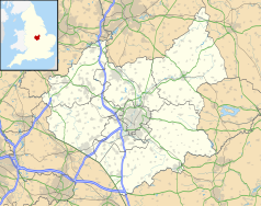
Położenie na mapie Leicestershire Contains Ordnance Survey data © Crown copyright and database right, CC BY-SA 3.0 | |
Położenie na mapie Wielkiej Brytanii (c) Karte: NordNordWest, Lizenz: Creative Commons by-sa-3.0 de | |
| Strona internetowa | |
| Portal | |
Ashby-de-la-Zouch (pot. Ashby) – miasto w Wielkiej Brytanii, w Anglii, w hrabstwie Leicestershire, w dystrykcie North West Leicestershire, w obrębie kompleksu National Forest. Zamieszkuje je 12 758 osób[1].
Nazwa
Ta rzadka jak na Anglię nazwa ma podwójny źródłosłów. Słowo Ashby jest pochodzenia anglo-duńskiego i oznacza „jesionową farmę” (duń. by(r) – wieś, osada, farma)[2], natomiast dodatek de la Zouch pochodzi z francuskiego i oznacza szlacheckiego właściciela pochodzenia francuskiego de la Souche, który objął tę farmę w XII wieku[3].
Historia
W XV wieku powstał zamek, w którym sir Walter Scott umieścił akcję powieści Ivanhoe.
Przypisy
- ↑ Census 2001 Area Profile (ang.). [dostęp 2008-11-06].
- ↑ Leicestershire (ang.). [dostęp 2008-11-06].
- ↑ Ashby de la Zouch Tourist Information (ang.). [dostęp 2008-11-06].
Media użyte na tej stronie
(c) Karte: NordNordWest, Lizenz: Creative Commons by-sa-3.0 de
Location map of the United Kingdom
Flag of England. Saint George's cross (a red cross on a white background), used as the Flag of England, the Italian city of Genoa and various other places.
Contains Ordnance Survey data © Crown copyright and database right, CC BY-SA 3.0
Map of Leicestershire, UK with the following information shown:
- Administrative borders
- Coastline, lakes and rivers
- Roads and railways
- Urban areas
Equirectangular map projection on WGS 84 datum, with N/S stretched 160%
Geographic limits:
- West: 1.80W
- East: 0.50W
- North: 53.00N
- South: 52.36N


